ꯐꯥꯏꯜ:View on Gyakar (edited).jpg
.jpg)
ꯃꯁꯤꯒꯤ ꯄ꯭ꯔꯚꯤꯌꯨ ꯑꯁꯤꯒꯤ ꯁꯥꯏꯓ: ২২০ × ১৫৩ ꯄꯤꯛꯆꯦꯜꯁ. ꯑꯇꯩ ꯁꯦꯡꯅ ꯌꯦꯡꯕ ꯌꯥꯕ: ৩২০ × ২২২ ꯄꯤꯛꯆꯦꯜꯁ | ৫,৪৭২ × ৩,৮০০ ꯄꯤꯛꯆꯦꯜꯁ.
ꯐꯥꯏꯜ ꯑꯁꯦꯡꯕ (৫,৪৭২ × ৩,৮০০ ꯄꯤꯛꯆꯦꯜꯁ, ꯐꯥꯏꯜ ꯆꯥꯎꯕꯒꯤ ꯆꯥꯡ: ১২.৯৮ MB, MIME ꯃꯈꯜ: image/jpeg)
ꯑꯇꯦꯟꯕꯥ ꯁꯟꯗꯣꯛꯅꯥ ꯇꯥꯛꯄꯥ
| ꯁꯟꯗꯣꯛꯅꯥ ꯇꯥꯛꯄꯥView on Gyakar (edited).jpg |
English: Majestic view on the village of Gyakar surrounded by a poplar grove and the summits of the Damodar Himal, the Purkung Himal and the Annapurnas. We were so lucky with the weather, having such a visibility all day long is not that common even in October after the monsoon.
Notice the suspended bridge over the deep canyon on the left.
Українська: Вид на село Г'якар, оточене тополиним гаєм, у Верхньому Мустангському регіоні Непалу. Вдалині видно вершини Дамодар-Гімал, Пуркунг-Гімал та Аннапурна. Підвісний міст через глибокий каньйон (ліворуч) з'єднує його із сусіднім селом Челе, а звідти — з рештою Непалу. |
| ꯆꯩꯆꯠ | Taken on ꯲꯳ ꯑꯣꯛꯇꯣꯕꯔ ꯲꯰꯱꯴, ꯱꯱:꯲꯴:꯵꯳ |
| ꯍꯧꯔꯛꯐꯛ |
This file was derived from: View on Gyakar.jpg |
| ꯄꯨꯊꯣꯛꯂꯤꯕ ꯃꯤ |
|
| Other versions |
|

| Camera location |  | View this and other nearby images on: OpenStreetMap |  28.943808; 83.805482 28.943808; 83.805482 |
|---|
 |
This is a retouched picture, which means that it has been digitally altered from its original version. Modifications: Dust stop removed, noise reduced. Modifications made by UnpetitproleX.
|
|
This is a retouched picture, which means that it has been digitally altered from its original version. Modifications: Added a little bit more sky. Modifications made by Aristeas.
|
Assessment
|


.jpg)
.jpg¶ms=028.943808_N_0083.805482_E_globe:Earth_type:camera__&language=mni)


|
This image was selected as picture of the day on Wikimedia Commons for 21 October 2025. It was captioned as follows: English: View of the village of Gyakar surrounded by a poplar grove in the Upper Mustang region of Nepal. The summits of the Damodar Himal, the Purkung Himal and the Annapurnas are visible in the distance. A suspended bridge over the deep canyon (left) connects it to the neighbouring Chele village and thence to the rest of Nepal. Other languages:
Čeština: Pohled na vesnici Gyakar obklopenou topolovým hájem v Lo („království Mustang”) na severu नेपाल (Nepál). Vzdáleně jsou vidět vrcholy pohoří हिमालय (Himálaj)[1]. Přes hluboký kaňon (vlevo) visí most, který ji spojuje se sousední vesnicí Chele a dále se pak připojí k zbytku Nepálu. English: View of the village of Gyakar surrounded by a poplar grove in the Upper Mustang region of Nepal. The summits of the Damodar Himal, the Purkung Himal and the Annapurnas are visible in the distance. A suspended bridge over the deep canyon (left) connects it to the neighbouring Chele village and thence to the rest of Nepal. Español: Vista del pueblo de Gyakar, rodeado de un bosque de álamos, en la región del Alto Mustang, Nepal. Las cumbres del Damodar Himal, el Purkung Himal y el macizo del Annapurna se divisan a lo lejos. Un puente colgante sobre el profundo cañón (izquierda) conecta Gyakar con el vecino pueblo de Chele y desde allí con el resto de Nepal. Euskara: Gyakar herrixka, Nepalgo Goi Mustang eskualdeko makal zuhaizti batez inguratuta. Damodar Himaleko, Purkung Himaleko eta Annapurnako gailurrak ikus daitezke urrunean. Arroila sakonaren gaineko zubi eseki batek (ezkerrean) ondoko Chele herriarekin lotzen du, eta handik Nepaleko gainerako herriarekin. Magyar: Kilátás a nyárfaligettel körülvett Ghyakar falura, melyet balra a mély kanyonon átívelő függőhíd köt össze Chele faluval és Nepál többi részével. A távolban a Himalája Damodar-hegységének Pukung- és Annapurna-csúcsa látható (Felső-Mustang régió, Gandaki Pradesh, Nepál) Português: Vista da aldeia de Gyakar rodeada por um bosque de choupos na região do Alto Mustang, no Nepal. Os cumes do Damodar Himal, do Purkung Himal e do Annapurna são visíveis ao longe. Uma ponte suspensa sobre o profundo desfiladeiro (à esquerda) liga-a à aldeia vizinha de Chele e, daí, ao resto do Nepal. Македонски: Поглед на селото Ѓакар во областа Горен Мустанг, Непал. Українська: Вид на село Г'якар, оточене тополиним гаєм, у Верхньому Мустангському регіоні Непалу. Вдалині видно вершини Дамодар-Гімал, Пуркунг-Гімал та Аннапурна. Підвісний міст через глибокий каньйон (ліворуч) з'єднує його із сусіднім селом Челе, а звідти — з рештою Непалу. |
ꯑꯌꯥꯕꯥ
I, the copyright holder of this work, hereby publish it under the following license:


This file is licensed under the Creative Commons Attribution 3.0 Unported license.
- ꯅꯪꯒꯤ ꯀꯨꯁꯤ:
- ꯃꯌꯥꯝꯗꯥ ꯐꯪꯍꯟꯕꯥ – ꯊꯥꯕꯛ ꯑꯗꯨ ꯁꯤꯟꯖꯤꯟꯕꯥ, ꯌꯦꯟꯊꯣꯛ ꯎ ꯑꯃꯥꯗꯤ ꯃꯐꯝ ꯱ ꯗꯥ ꯆꯠꯍꯟꯂꯨ
- ꯑꯃꯨꯛꯀꯥ ꯌꯥꯟꯁꯤꯟꯅꯍꯟꯕꯥ – ꯊꯥꯕꯛꯇꯨꯒꯥ ꯆꯨꯁꯤꯟꯅꯍꯟꯕꯥ
- ꯃꯈꯥꯒꯤ ꯌꯥꯅꯕꯒꯤ ꯃꯈꯥ ꯄꯣꯟꯅ:
- ꯈꯣꯝꯒꯠꯂꯛꯄꯥ – ꯅꯪꯅ ꯆꯞꯆꯥꯕ ꯇꯧꯕꯤꯃꯜ ꯄꯤꯕꯤꯒꯗꯕꯅꯤ, ꯑꯌꯥꯕ ꯄꯤꯔꯤꯕꯁꯤꯡꯒ ꯁꯝꯅꯐꯝ ꯄꯤꯒꯗꯕꯅꯤ ꯑꯃꯁꯨꯡ ꯑꯍꯣꯡꯕ ꯈꯔꯥ ꯂꯩꯔꯗꯤ ꯃꯗꯨ ꯎꯠꯀꯗꯕꯅꯤ ꯫ ꯅꯪꯅ ꯃꯗꯨ ꯃꯔꯝ ꯂꯩꯅ ꯇꯧꯒꯗꯕꯅꯤ, ꯑꯗꯨꯕꯨ ꯑꯌꯥꯕ ꯄꯥꯏꯔꯤꯕꯗꯨꯅ ꯍꯥꯏꯔꯛꯄ ꯃꯑꯣꯡ ꯅꯠꯇ꯭ꯔꯒ ꯅꯪꯅ ꯁꯤꯖꯤꯟꯅꯕ ꯃꯑꯣꯡꯗ ꯇꯧꯔꯣꯏꯗꯕꯅꯤ ꯫
| Annotations InfoField | This image is annotated: View the annotations at Commons |
.jpg)
4453
294
376
274
5472
3800
Tilicho Peak
534
137
369
349
5472
3800
Khatung Kang
- ↑ दामोदर हिमालय, Purkung Himal a अन्नपूर्ण
Captions
Add a one-line explanation of what this file represents
曾經木斯塘王國的所在地,現在屬於尼泊爾的木斯塘縣,樺樹林環繞著村落Gyaka
かつてムスタン王国の所在地であり、現在はネパールのムスタン地区の一部であるギャカ村は、白樺の森に囲まれています。
ꯐꯥꯏꯜꯒꯤ ꯄꯨꯋꯥꯔꯤ
ꯆꯩꯆꯠ/ꯃꯇꯝꯗ ꯅꯝꯃꯨ ꯃꯇꯝ ꯑꯗꯨꯗ ꯐꯥꯏꯜ ꯑꯗꯨ ꯎꯅꯕ
| ꯆꯩꯆꯠ/ꯃꯇꯝ | ꯈꯨꯠꯄꯤꯈꯨꯖꯤꯟ | ꯄꯥꯛ ꯆꯥꯎꯕꯥ | ꯁꯤꯖꯤꯟꯅꯔꯤꯕ | ꯑꯄꯥꯝꯕ ꯐꯣꯡꯗꯣꯛ ꯎ | |
|---|---|---|---|---|---|
| ꯍꯧꯖꯤꯛꯀꯤ | ꯲꯲:꯲꯲, ꯳ ꯖꯨꯟ ꯲꯰꯲꯲ | 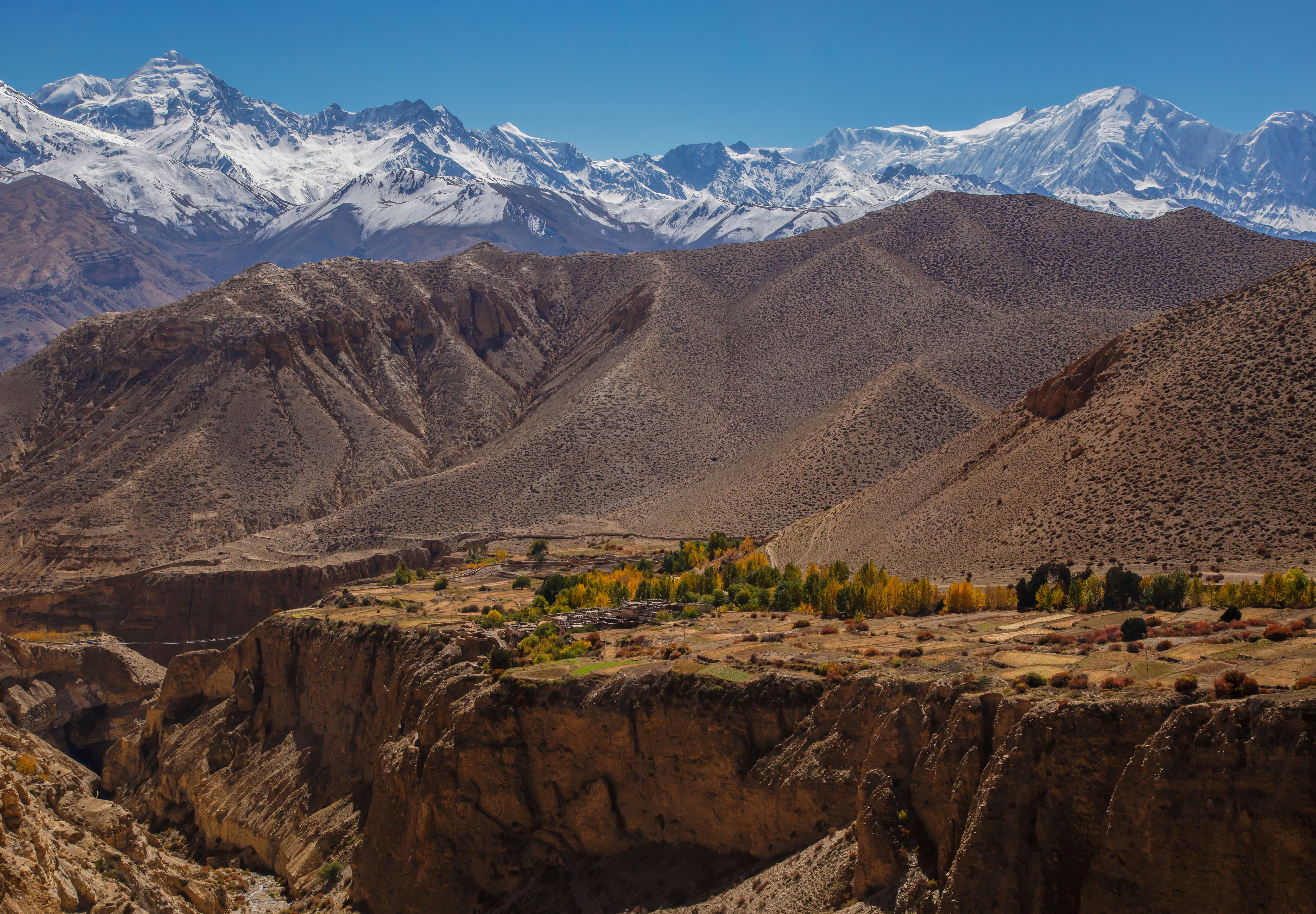 | ৫,৪৭২ × ৩,৮০০ (১২.৯৮ MB) | smartcommons>Aristeas | =={{int:filedesc}}== {{Information |description={{en|1=Majestic view on the village of Gyakar surrounded by a poplar grove and the summits of the Damodar Himal, the Purkung Himal and the Annapurnas. We were so lucky with the weather, having such a visibility all day long is not that common even in October after the monsoon. Notice the suspended bridge over the deep canyon on the left.}} |date={{Taken on|2014-10-23 11:24:53|location=Nepal}} |source={{Derived from|File:View on Gyakar.jpg}} |aut... |
ꯐꯥꯏꯜꯒꯤ ꯁꯤꯖꯤꯟꯅꯐꯝ
ꯃꯁꯤꯒꯤ ꯐꯥꯏꯜ ꯁꯤ ꯁꯤꯖꯤꯟꯅꯕ ꯂꯃꯥꯏꯁꯤꯡ ꯂꯩꯇꯦ ꯫
.jpg)