ꯐꯥꯏꯜ:Treasury Annex.JPG

ꯃꯁꯤꯒꯤ ꯄ꯭ꯔꯚꯤꯌꯨ ꯑꯁꯤꯒꯤ ꯁꯥꯏꯓ: ২২০ × ১৫১ ꯄꯤꯛꯆꯦꯜꯁ. ꯑꯇꯩ ꯁꯦꯡꯅ ꯌꯦꯡꯕ ꯌꯥꯕ: ৩২০ × ২২০ ꯄꯤꯛꯆꯦꯜꯁ | ৮২৮ × ৫৭০ ꯄꯤꯛꯆꯦꯜꯁ.
ꯐꯥꯏꯜ ꯑꯁꯦꯡꯕ (৮২৮ × ৫৭০ ꯄꯤꯛꯆꯦꯜꯁ, ꯐꯥꯏꯜ ꯆꯥꯎꯕꯒꯤ ꯆꯥꯡ: ১০৯ KB, MIME ꯃꯈꯜ: image/jpeg)

| ꯁꯟꯗꯣꯛꯅꯥ ꯇꯥꯛꯄꯥTreasury Annex.JPG |
English: The Freedman's Bank Building, previously known as the United States Treasury Annex, is located at 701 Madison Place NW across the street from the Treasury Building in Washington, D.C. The Treasury Annex houses the Office of Foreign Assets Control, the Treasury Library, and the headquarters and main branch of the Treasury Department Federal Credit Union. Designed by architect Cass Gilbert, construction of the Beaux-Arts style building was completed in 1919. The building is designated a contributing property to the Lafayette Square Historic District and Fifteenth Street Financial Historic District and is listed on the District of Columbia Inventory of Historic Sites. The building was renamed in 2016 in honor of the Freedman's Savings Bank, which once stood on the site. |
| ꯆꯩꯆꯠ | |
| ꯍꯧꯔꯛꯐꯛ | ꯏꯁꯥ ꯏꯊꯟꯇꯒꯤ ꯑꯣꯏꯕꯥ ꯊꯕꯛ |
| ꯄꯨꯊꯣꯛꯂꯤꯕ ꯃꯤ | APK |
| ꯑꯌꯥꯕ ꯂꯧꯕ (ꯃꯁꯤꯒꯤ ꯐꯥꯏꯜꯁꯤ ꯑꯃꯨꯛ ꯍꯟꯅꯥ ꯁꯤꯖꯤꯟꯅꯕꯥ) |
I, the copyright holder of this work, hereby publish it under the following license:    ꯐꯥꯏꯜ ꯑꯁꯤ ꯀ꯭ꯔꯤꯌꯦꯇꯤꯚ ꯀꯣꯃꯣꯟꯁꯀꯤ Attribution-Share Alike 3.0 Unported ꯑꯌꯥꯕꯒꯤ ꯃꯈꯥꯗ ꯌꯥꯎꯕꯅꯤ ꯫
|
| Camera location |  | View this and other nearby images on: OpenStreetMap |  38.898763; -77.034985 38.898763; -77.034985 |
|---|

Captions
Add a one-line explanation of what this file represents
ꯐꯥꯏꯜꯒꯤ ꯄꯨꯋꯥꯔꯤ
ꯆꯩꯆꯠ/ꯃꯇꯝꯗ ꯅꯝꯃꯨ ꯃꯇꯝ ꯑꯗꯨꯗ ꯐꯥꯏꯜ ꯑꯗꯨ ꯎꯅꯕ
| ꯆꯩꯆꯠ/ꯃꯇꯝ | ꯈꯨꯠꯄꯤꯈꯨꯖꯤꯟ | ꯄꯥꯛ ꯆꯥꯎꯕꯥ | ꯁꯤꯖꯤꯟꯅꯔꯤꯕ | ꯑꯄꯥꯝꯕ ꯐꯣꯡꯗꯣꯛ ꯎ | |
|---|---|---|---|---|---|
| ꯍꯧꯖꯤꯛꯀꯤ | ꯱꯴:꯳꯱, ꯲꯴ ꯑꯦꯄꯔꯤꯜ ꯲꯰꯲꯲ | 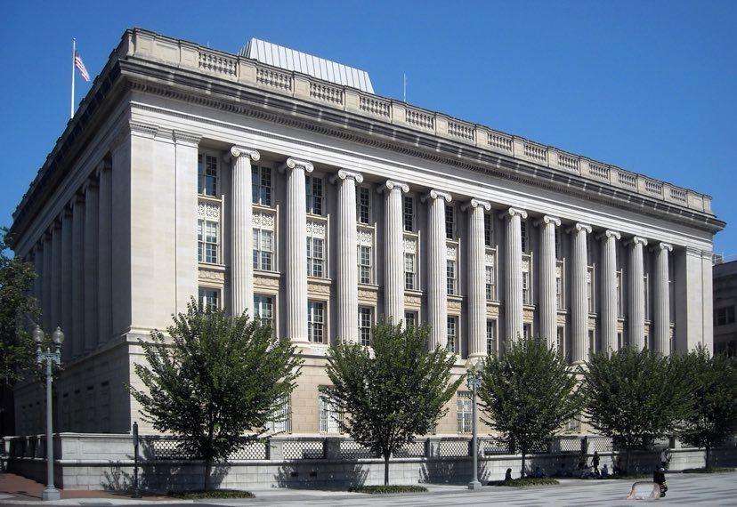 | ৮২৮ × ৫৭০ (১০৯ KB) | smartcommons>APK | angle |
ꯐꯥꯏꯜꯒꯤ ꯁꯤꯖꯤꯟꯅꯐꯝ
ꯃꯁꯤꯒꯤ ꯐꯥꯏꯜ ꯁꯤ ꯁꯤꯖꯤꯟꯅꯕ ꯂꯃꯥꯏꯁꯤꯡ ꯂꯩꯇꯦ ꯫
