ꯐꯥꯏꯜ:The Kosi, August 8, 2008.jpg

ꯃꯁꯤꯒꯤ ꯄ꯭ꯔꯚꯤꯌꯨ ꯑꯁꯤꯒꯤ ꯁꯥꯏꯓ: ২২০ × ২২০ ꯄꯤꯛꯆꯦꯜꯁ. ꯑꯇꯩ ꯁꯦꯡꯅ ꯌꯦꯡꯕ ꯌꯥꯕ: ২৪০ × ২৪০ ꯄꯤꯛꯆꯦꯜꯁ | ২,৭৩২ × ২,৭৩২ ꯄꯤꯛꯆꯦꯜꯁ.
ꯐꯥꯏꯜ ꯑꯁꯦꯡꯕ (২,৭৩২ × ২,৭৩২ ꯄꯤꯛꯆꯦꯜꯁ, ꯐꯥꯏꯜ ꯆꯥꯎꯕꯒꯤ ꯆꯥꯡ: ২.১৬ MB, MIME ꯃꯈꯜ: image/jpeg)

ꯑꯇꯦꯟꯕꯥ ꯁꯟꯗꯣꯛꯅꯥ ꯇꯥꯛꯄꯥ
| ꯁꯟꯗꯣꯛꯅꯥ ꯇꯥꯛꯄꯥThe Kosi, August 8, 2008.jpg |
English: The braided channels of the Kosi River curve westward out of Nepal in a “c” shape before flowing into the Ganges below the lower edge of this satellite image. In this type of image, water is usually dark blue and black. Both sediment-laden water and water-saturated earth are a lighter shade of blue. The channels of the Kosi are silvery from reflected sunlight. |
| ꯆꯩꯆꯠ | |
| ꯍꯧꯔꯛꯐꯛ | NASA Earth Observatory |
| ꯄꯨꯊꯣꯛꯂꯤꯕ ꯃꯤ | Images courtesy the MODIS Rapid Response Team at NASA GSFC. |
This image was generated by the Moderate Resolution Imaging Spectroradiometer (MODIS) on NASA’s Terra satellite.
ꯑꯌꯥꯕꯥ
| Public domainPublic domainfalsefalse |

|
This file is in the public domain in the United States because it was solely created by NASA. NASA copyright policy states that "NASA material is not protected by copyright unless noted". (See Template:PD-USGov, NASA copyright policy page or JPL Image Use Policy.) |  |
 |
Warnings:
|

Captions
Add a one-line explanation of what this file represents
ꯐꯥꯏꯜꯒꯤ ꯄꯨꯋꯥꯔꯤ
ꯆꯩꯆꯠ/ꯃꯇꯝꯗ ꯅꯝꯃꯨ ꯃꯇꯝ ꯑꯗꯨꯗ ꯐꯥꯏꯜ ꯑꯗꯨ ꯎꯅꯕ
| ꯆꯩꯆꯠ/ꯃꯇꯝ | ꯈꯨꯠꯄꯤꯈꯨꯖꯤꯟ | ꯄꯥꯛ ꯆꯥꯎꯕꯥ | ꯁꯤꯖꯤꯟꯅꯔꯤꯕ | ꯑꯄꯥꯝꯕ ꯐꯣꯡꯗꯣꯛ ꯎ | |
|---|---|---|---|---|---|
| ꯍꯧꯖꯤꯛꯀꯤ | ꯲꯲:꯲꯴, ꯲꯳ ꯃꯦ ꯲꯰꯰꯹ | 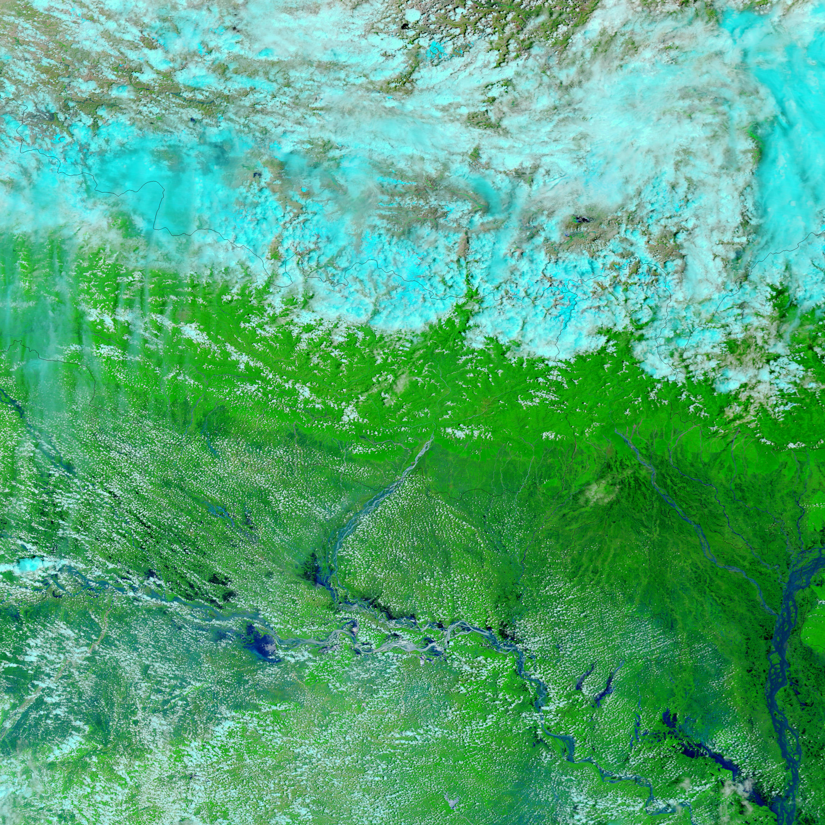 | ২,৭৩২ × ২,৭৩২ (২.১৬ MB) | smartcommons>Originalwana | {{Information |Description={{en|1=The braided channels of the Kosi River curve westward out of Nepal in a “c” shape before flowing into the Ganges below the lower edge of this satellite image. In this type of image, water is usually dark blue and blac |
ꯐꯥꯏꯜꯒꯤ ꯁꯤꯖꯤꯟꯅꯐꯝ
ꯃꯁꯤꯒꯤ ꯐꯥꯏꯜ ꯁꯤ ꯁꯤꯖꯤꯟꯅꯕ ꯂꯃꯥꯏꯁꯤꯡ ꯂꯩꯇꯦ ꯫
