ꯐꯥꯏꯜ:The Blue Marble (remastered).jpg
.jpg)
ꯃꯁꯤꯒꯤ ꯄ꯭ꯔꯚꯤꯌꯨ ꯑꯁꯤꯒꯤ ꯁꯥꯏꯓ: ২২০ × ২২০ ꯄꯤꯛꯆꯦꯜꯁ. ꯑꯇꯩ ꯁꯦꯡꯅ ꯌꯦꯡꯕ ꯌꯥꯕ: ২৪০ × ২৪০ ꯄꯤꯛꯆꯦꯜꯁ | ৩,০০০ × ৩,০০০ ꯄꯤꯛꯆꯦꯜꯁ.
ꯐꯥꯏꯜ ꯑꯁꯦꯡꯕ (৩,০০০ × ৩,০০০ ꯄꯤꯛꯆꯦꯜꯁ, ꯐꯥꯏꯜ ꯆꯥꯎꯕꯒꯤ ꯆꯥꯡ: ৫.৪৪ MB, MIME ꯃꯈꯜ: image/jpeg)
কুমিল্লা
ꯑꯇꯦꯟꯕꯥ ꯁꯟꯗꯣꯛꯅꯥ ꯇꯥꯛꯄꯥ
The Blue Marble
  |
|||
|---|---|---|---|
| Photographer |
NASA/Apollo 17 crew; taken by either Harrison Schmitt or Ron Evans |
 | |
| Title |
The Blue Marble |
||
| ꯁꯔꯨꯛꯅꯤ | Apollo 17 | ||
| Object type | color photograph | ||
| Genre | astronaut photography | ||
| ꯁꯟꯗꯣꯛꯅꯥ ꯇꯥꯛꯄꯥ |
Full disk view of the Earth taken on December 7, 1972, by the crew of the Apollo 17 spacecraft en route to the Moon at a distance of about 29,400 kilometres (18,300 mi). It shows Africa, Antarctica, and the Arabian Peninsula. |
||
| ꯆꯩꯆꯠ |
꯷ ꯗꯤꯁꯦꯝꯕꯔ ꯱꯹꯷꯲ date QS:P571,+1972-12-07T00:00:00Z/11 |
||
| Medium | 1 photograph: Hasselblad 500EL, Zeiss Planar 80 mm f/2.8 and 70mm Kodak Ektachrome film of type SO-368 | ||
| Collection |
|
||
| Notes |
The end of most film magazines used on the Apollo missions include a photograph, presumably taken on earth, of a "KODAK Color Control Patch" on a chart containing mission and camera data. This color chart was used to calibrate the above photograph to better approximate real-world colors. Earth disk center rough coordinates: 26°19’49”S 37°25’13”E |
||
| References | https://tothemoon.ser.asu.edu/gallery/Apollo/17/Hasselblad%20500EL%2070%20mm | ||
| ꯍꯧꯔꯛꯐꯛ | https://tothemoon.ser.asu.edu/gallery/Apollo/17/Hasselblad%20500EL%2070%20mm https://www.flickr.com/photos/projectapolloarchive/21081863984/ | ||
| Other versions |
[]
Derivative works:
|
||


.jpg)
.jpg)
.jpg)


.jpg)


.jpg)
.jpg¶ms=-26.330278_N_0037.420278_E_globe:Earth_class:object_type:object__&language=en)
| Object location |  | View this and other nearby images on: OpenStreetMap |  -26.330278; 37.420278 -26.330278; 37.420278 |
|---|
.jpg¶ms=-26.330278_N_0037.420278_E_globe:Earth_class:object_type:object__&language=mni)
ꯑꯌꯥꯕꯥ
| Public domainPublic domainfalsefalse |

|
This file is in the public domain in the United States because it was solely created by NASA. NASA copyright policy states that "NASA material is not protected by copyright unless noted". (See Template:PD-USGov, NASA copyright policy page or JPL Image Use Policy.) |  |
 |
Warnings:
|

Captions
Add a one-line explanation of what this file represents
Photograph of Planet Earth from space
A full disk of the Earth, centered on the sea off Mozambique, as taken by the crew of Apollo 17 on 7 December 1972, from 29,400 km (18,300 mi) above. Africa, Southwest Asia and Antarctica are shown.
כדור הארץ מהחלל
Fotografia The Blue Marble obtida durante a missão Apollo 17, em 1972
Une face complète de la Terre, centrée sur le canal du Mozambique. La photo a été prise par l'équipage d'Apollo 17, le 7 décembre 1972, à 29 400 km de hauteur. On peut y distinguer l'Afrique, l'Antarctique et la péninsule arabique.
كوكب الأرض
ꯐꯥꯏꯜꯒꯤ ꯄꯨꯋꯥꯔꯤ
ꯆꯩꯆꯠ/ꯃꯇꯝꯗ ꯅꯝꯃꯨ ꯃꯇꯝ ꯑꯗꯨꯗ ꯐꯥꯏꯜ ꯑꯗꯨ ꯎꯅꯕ
| ꯆꯩꯆꯠ/ꯃꯇꯝ | ꯈꯨꯠꯄꯤꯈꯨꯖꯤꯟ | ꯄꯥꯛ ꯆꯥꯎꯕꯥ | ꯁꯤꯖꯤꯟꯅꯔꯤꯕ | ꯑꯄꯥꯝꯕ ꯐꯣꯡꯗꯣꯛ ꯎ | |
|---|---|---|---|---|---|
| ꯍꯧꯖꯤꯛꯀꯤ | ꯰꯱:꯴꯲, ꯸ ꯖꯨꯂꯥꯏ ꯲꯰꯲꯴ | 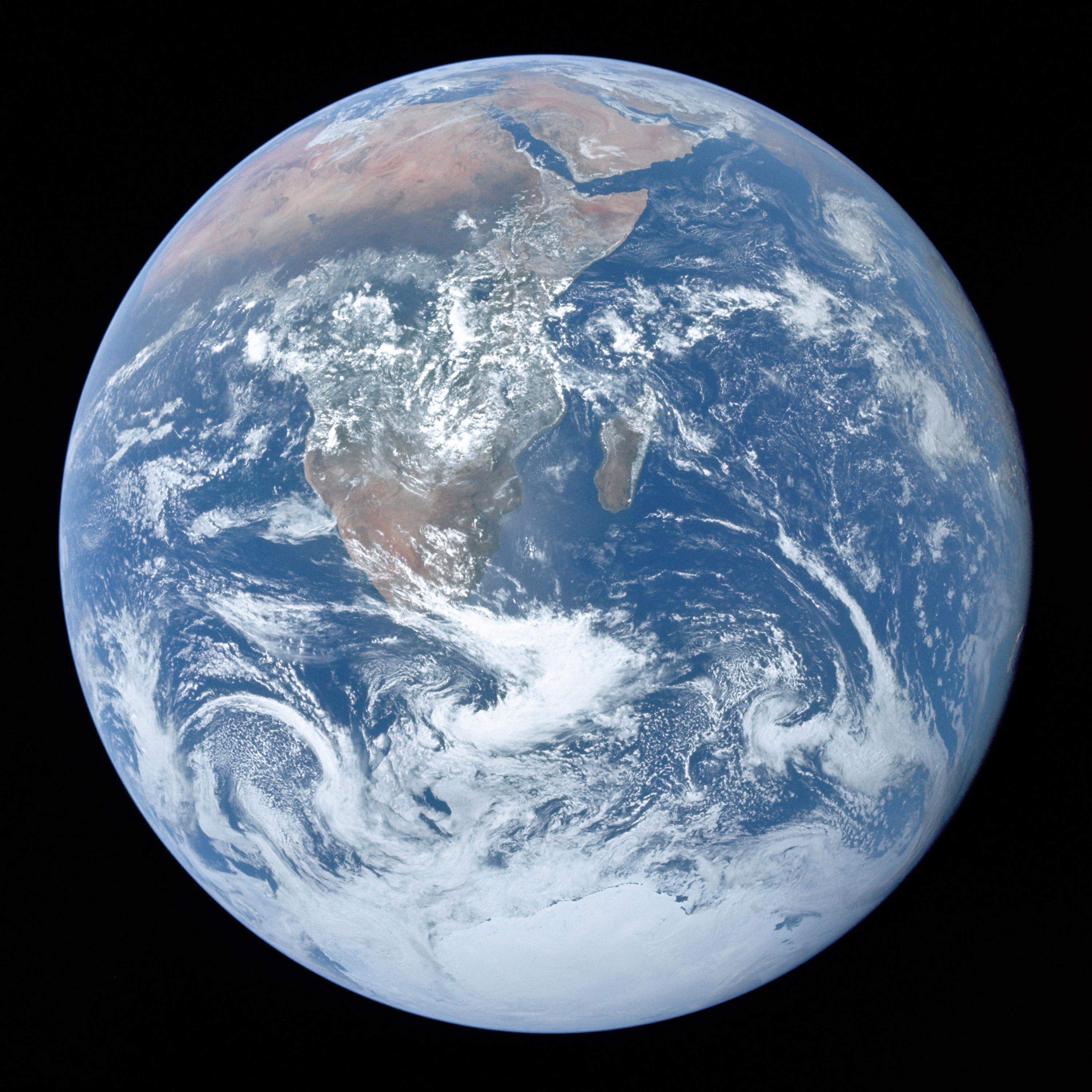 | ৩,০০০ × ৩,০০০ (৫.৪৪ MB) | smartcommons>Gabldotink | jpegoptim --keep-all --strip-none --all-normal |
ꯐꯥꯏꯜꯒꯤ ꯁꯤꯖꯤꯟꯅꯐꯝ
ꯃꯁꯤꯒꯤ ꯐꯥꯏꯜ ꯁꯤ ꯁꯤꯖꯤꯟꯅꯕ ꯂꯃꯥꯏꯁꯤꯡ ꯂꯩꯇꯦ ꯫
.jpg)