ꯐꯥꯏꯜ:Sundarbans.jpg

ꯃꯁꯤꯒꯤ ꯄ꯭ꯔꯚꯤꯌꯨ ꯑꯁꯤꯒꯤ ꯁꯥꯏꯓ: ২২০ × ১৪৭ ꯄꯤꯛꯆꯦꯜꯁ. ꯑꯇꯩ ꯁꯦꯡꯅ ꯌꯦꯡꯕ ꯌꯥꯕ: ৩২০ × ২১৩ ꯄꯤꯛꯆꯦꯜꯁ | ৭,২০০ × ৪,৮০০ ꯄꯤꯛꯆꯦꯜꯁ.
ꯐꯥꯏꯜ ꯑꯁꯦꯡꯕ (৭,২০০ × ৪,৮০০ ꯄꯤꯛꯆꯦꯜꯁ, ꯐꯥꯏꯜ ꯆꯥꯎꯕꯒꯤ ꯆꯥꯡ: ৪ MB, MIME ꯃꯈꯜ: image/jpeg)

ꯑꯇꯦꯟꯕꯥ ꯁꯟꯗꯣꯛꯅꯥ ꯇꯥꯛꯄꯥ
| ꯁꯟꯗꯣꯛꯅꯥ ꯇꯥꯛꯄꯥSundarbans.jpg |
English: This NASA satellite image was created by merging Landsat 7 satellite observations from November 24, 1999, and November 17 and 26, 2000. It shows the forest in the protected area. The Sundarbans appears deep green, surrounded to the north by a landscape of agricultural lands, which appear lighter green, towns, which appear tan, and streams, which are blue. Ponds for shrimp aquaculture, especially in Bangladesh, sit right at the edge of the protected area, a potential problem for the water quality and biodiversity of the area. The forest may also be under stress from environmental disturbance occurring thousands of kilometers away, such as deforestation in the Himalaya Mountains far to the north. NASA image created by Jesse Allen, Earth Observatory, using data obtained from the University of Maryland’s Global Land Cover Facility.
Français : Cette image satellite montre la forêt dans le secteur protégé. La région des Sundarbans semble vert-foncé, entouré au nord par un paysage de régions agricoles, qui apparaissent d’un vert plus léger, les villes, sont en brun, et les cours d’eau sont bleus. Les étangs pour l'aquiculture de crevette, particulièrement au Bangladesh, se trouvent juste a la limite du secteur protégé, un problème potentiel pour la qualité de l'eau et la biodiversité du secteur. La forêt peut également être sous l'effet de perturbations environnementales à des milliers de kilomètres de distance, comme le déboisement des montagnes de l'Himalaya loin au nord. |
| ꯆꯩꯆꯠ | |
| ꯍꯧꯔꯛꯐꯛ | [1] |
| ꯄꯨꯊꯣꯛꯂꯤꯕ ꯃꯤ | NASA image created by Jesse Allen, Earth Observatory, using data obtained from the University of Maryland’s Global Land Cover Facility. |
ꯑꯌꯥꯕꯥ
| Public domainPublic domainfalsefalse |

|
This file is in the public domain in the United States because it was solely created by NASA. NASA copyright policy states that "NASA material is not protected by copyright unless noted". (See Template:PD-USGov, NASA copyright policy page or JPL Image Use Policy.) |  |
 |
Warnings:
|

Captions
Add a one-line explanation of what this file represents
ꯐꯥꯏꯜꯒꯤ ꯄꯨꯋꯥꯔꯤ
ꯆꯩꯆꯠ/ꯃꯇꯝꯗ ꯅꯝꯃꯨ ꯃꯇꯝ ꯑꯗꯨꯗ ꯐꯥꯏꯜ ꯑꯗꯨ ꯎꯅꯕ
| ꯆꯩꯆꯠ/ꯃꯇꯝ | ꯈꯨꯠꯄꯤꯈꯨꯖꯤꯟ | ꯄꯥꯛ ꯆꯥꯎꯕꯥ | ꯁꯤꯖꯤꯟꯅꯔꯤꯕ | ꯑꯄꯥꯝꯕ ꯐꯣꯡꯗꯣꯛ ꯎ | |
|---|---|---|---|---|---|
| ꯍꯧꯖꯤꯛꯀꯤ | ꯱꯵:꯳꯰, ꯲꯹ ꯖꯥꯅꯨꯋꯥꯔꯤ ꯲꯰꯰꯸ | 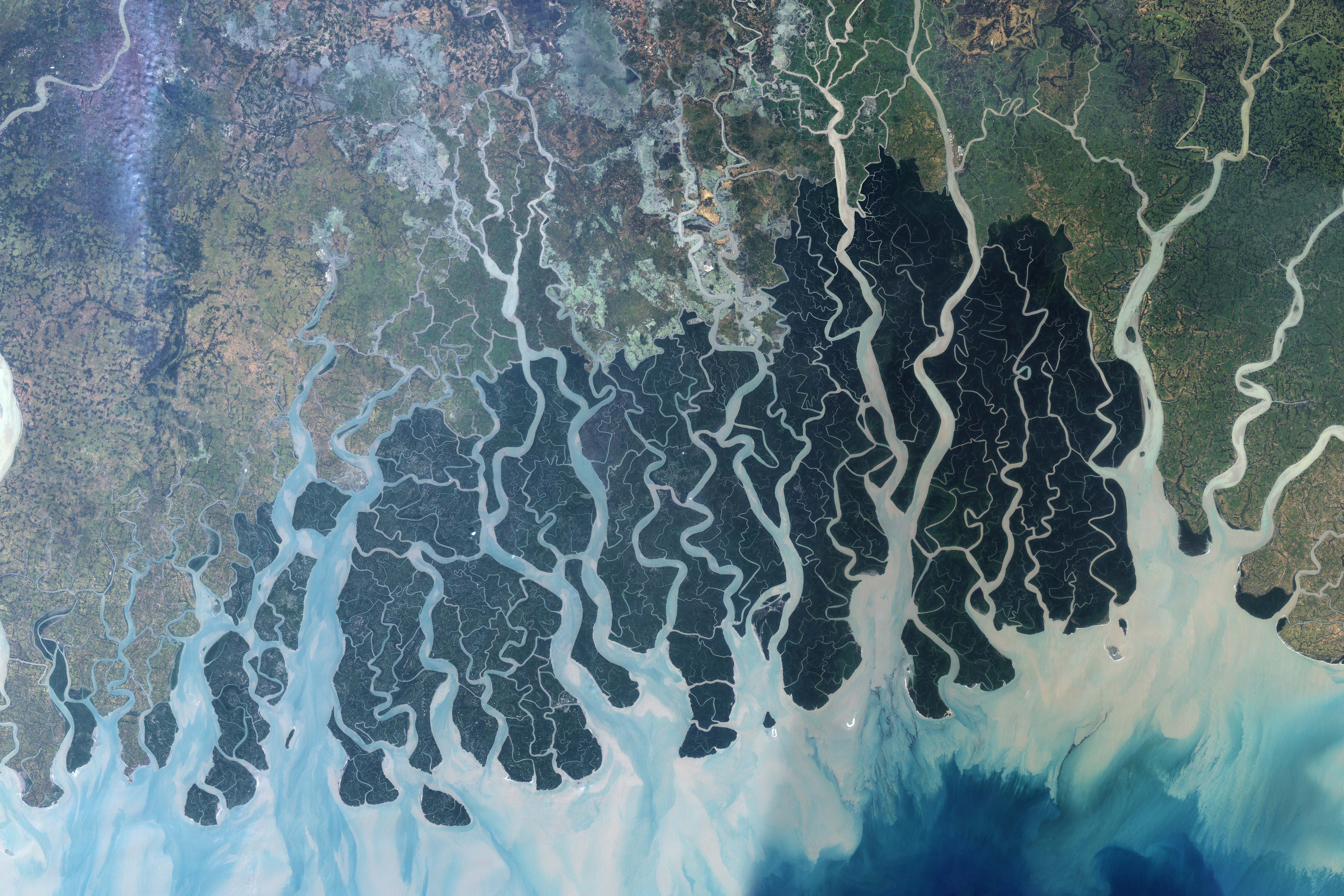 | ৭,২০০ × ৪,৮০০ (৪ MB) | smartcommons>Armanaziz | {{Information |Description=This satellite image shows the forest in the protected area. The Sundarbans appears deep green, surrounded to the north by a landscape of agricultural lands, which appear lighter green, towns, which appear tan, and streams, whic |
ꯐꯥꯏꯜꯒꯤ ꯁꯤꯖꯤꯟꯅꯐꯝ
ꯃꯁꯤꯒꯤ ꯐꯥꯏꯜ ꯁꯤ ꯁꯤꯖꯤꯟꯅꯕ ꯂꯃꯥꯏꯁꯤꯡ ꯂꯩꯇꯦ ꯫
