Jump to content

ꯐꯥꯏꯜ:Sumatra Volcanoes.png

ꯚꯥꯔꯠꯄꯤꯗꯤꯌꯥ ꯗꯒꯤ

ꯐꯥꯏꯜ ꯑꯁꯦꯡꯕ (৬০০ × ৫২৭ ꯄꯤꯛꯆꯦꯜꯁ, ꯐꯥꯏꯜ ꯆꯥꯎꯕꯒꯤ ꯆꯥꯡ: ১৪১ KB, MIME ꯃꯈꯜ: image/png)

ꯃꯁꯤꯒꯤ ꯐꯥꯏꯜ ꯑꯁꯤ a shared repository ꯗꯒꯤꯅꯤ ꯑꯃꯁꯨꯡ ꯑꯇꯩ ꯊꯧꯔꯥꯁꯁꯤꯡꯅꯥ ꯁꯤꯖꯤꯟꯅꯩ ꯫ ꯃꯁꯤꯗ ꯁꯟꯗꯣꯛꯅꯥ ꯇꯥꯛꯄ ꯑꯁꯤ ꯐꯥꯏꯜ ꯁꯟꯗꯣꯛꯅꯥ ꯍꯥꯏꯕ ꯂꯃꯥꯏ ꯃꯈꯥꯒꯤ ꯁꯤꯗ ꯎꯨꯠꯂꯦ ꯫

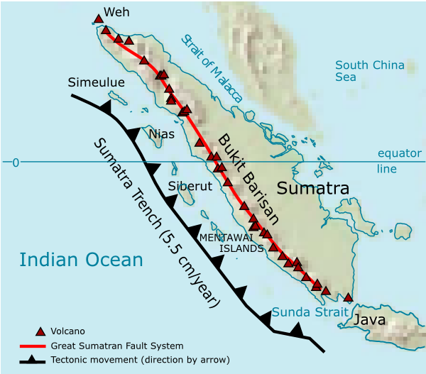
ꯁꯟꯗꯣꯛꯅꯥ ꯇꯥꯛꯄꯥSumatra Volcanoes.png Volcanoes on Sumatra island. See en:List of volcanoes in Indonesia.
ꯆꯩꯆꯠ
ꯍꯧꯔꯛꯐꯛ ꯏꯁꯥ ꯏꯊꯟꯇꯒꯤ ꯑꯣꯏꯕꯥ ꯊꯕꯛ
ꯄꯨꯊꯣꯛꯂꯤꯕ ꯃꯤ User:Indon (myself)
ꯑꯌꯥꯕ ꯂꯧꯕ
(ꯃꯁꯤꯒꯤ ꯐꯥꯏꯜꯁꯤ ꯑꯃꯨꯛ ꯍꯟꯅꯥ ꯁꯤꯖꯤꯟꯅꯕꯥ)
I, the copyright holder of this work, hereby publish it under the following licenses:
GNU head ꯁꯤꯟꯗꯣꯛꯅꯕ ꯑꯌꯥꯕꯗꯨ ꯄꯤꯔꯦ, ꯌꯦꯟꯊꯣꯛꯎ ꯑꯃꯁꯨꯡ/ꯅꯠꯇ꯭ꯔꯒ ꯃꯑꯣꯡ ꯱ꯗ ꯁꯦꯝꯗꯣꯛꯎ ꯃꯁꯤꯒꯤ ꯐꯥꯏꯜ ꯑꯁꯤ ꯖꯤ•ꯑꯦꯟ•ꯌꯨ ꯃꯃꯜ ꯇꯤꯡꯗꯕ ꯗꯣꯀꯨꯃꯦꯟꯇꯦꯁꯟꯒꯤ ꯑꯌꯥꯕ ꯌꯥꯅꯕꯒꯤ ꯃꯈꯥꯗ, ꯚꯔꯖꯟ ꯱.꯲ ꯅꯠꯇ꯭ꯔꯒ ꯇꯨꯡꯗ ꯂꯥꯛꯀꯗꯕ ꯚꯔꯖꯟ Free Software Foundationꯅ ꯐꯣꯡꯗꯣꯛꯂꯕ; ꯂꯣꯏꯅꯅ ꯈꯦꯠꯅꯕ ꯁꯔꯨꯛꯁꯤꯡ ꯌꯥꯎꯗꯅ, ꯂꯥꯏꯔꯤꯛꯀꯤ ꯃꯃꯥꯡꯒꯤ ꯃꯈꯨꯝ ꯌꯥꯎꯗꯕꯤ, ꯑꯃꯗꯤ ꯂꯥꯏꯔꯤꯛꯀꯤ ꯑꯔꯣꯏꯕ ꯆꯦꯈꯨꯝ ꯌꯥꯎꯗꯕꯤ ꯫ ꯁꯤꯟꯗꯣꯛꯄ ꯌꯥꯕꯒꯤ ꯑꯌꯥꯕꯁꯤꯡꯁꯤ GNU Free Documentation Licenseꯒꯤ ꯁ꯭ꯔꯨꯛꯁꯤꯡꯗ ꯌꯥꯎꯔꯦhttp://www.gnu.org/copyleft/fdl.htmlGFDLGNU Free Documentation Licensetruetrue
w:en:Creative Commons
ꯈꯣꯝꯒꯠꯂꯛꯄꯥ ꯃꯥꯟꯅꯕꯥ ꯁꯥꯔꯨꯛ
ꯐꯥꯏꯜ ꯑꯁꯤ ꯀ꯭ꯔꯤꯌꯦꯇꯤꯚ ꯀꯣꯃꯣꯟꯁꯀꯤ Attribution-Share Alike 3.0 Unported ꯑꯌꯥꯕꯒꯤ ꯃꯈꯥꯗ ꯌꯥꯎꯕꯅꯤ ꯫
ꯅꯪꯒꯤ ꯀꯨꯁꯤ:
  • ꯃꯌꯥꯝꯗꯥ ꯐꯪꯍꯟꯕꯥ – ꯊꯥꯕꯛ ꯑꯗꯨ ꯁꯤꯟꯖꯤꯟꯕꯥ, ꯌꯦꯟꯊꯣꯛ ꯎ ꯑꯃꯥꯗꯤ ꯃꯐꯝ ꯱ ꯗꯥ ꯆꯠꯍꯟꯂꯨ
  • ꯑꯃꯨꯛꯀꯥ ꯌꯥꯟꯁꯤꯟꯅꯍꯟꯕꯥ – ꯊꯥꯕꯛꯇꯨꯒꯥ ꯆꯨꯁꯤꯟꯅꯍꯟꯕꯥ
ꯃꯈꯥꯒꯤ ꯌꯥꯅꯕꯒꯤ ꯃꯈꯥ ꯄꯣꯟꯅ:
  • ꯈꯣꯝꯒꯠꯂꯛꯄꯥ – ꯅꯪꯅ ꯆꯞꯆꯥꯕ ꯇꯧꯕꯤꯃꯜ ꯄꯤꯕꯤꯒꯗꯕꯅꯤ, ꯑꯌꯥꯕ ꯄꯤꯔꯤꯕꯁꯤꯡꯒ ꯁꯝꯅꯐꯝ ꯄꯤꯒꯗꯕꯅꯤ ꯑꯃꯁꯨꯡ ꯑꯍꯣꯡꯕ ꯈꯔꯥ ꯂꯩꯔꯗꯤ ꯃꯗꯨ ꯎꯠꯀꯗꯕꯅꯤ ꯫ ꯅꯪꯅ ꯃꯗꯨ ꯃꯔꯝ ꯂꯩꯅ ꯇꯧꯒꯗꯕꯅꯤ, ꯑꯗꯨꯕꯨ ꯑꯌꯥꯕ ꯄꯥꯏꯔꯤꯕꯗꯨꯅ ꯍꯥꯏꯔꯛꯄ ꯃꯑꯣꯡ ꯅꯠꯇ꯭ꯔꯒ ꯅꯪꯅ ꯁꯤꯖꯤꯟꯅꯕ ꯃꯑꯣꯡꯗ ꯇꯧꯔꯣꯏꯗꯕꯅꯤ ꯫
  • ꯃꯥꯟꯅꯕꯥ ꯁꯥꯔꯨꯛ – ꯀꯔꯤꯒꯨꯝꯅ ꯅꯪꯅ ꯌꯥꯟꯁꯤꯟꯅꯔꯕ, ꯍꯣꯡꯗꯣꯛꯍꯟꯂꯕ, ꯅꯠꯇ꯭ꯔꯒ ꯄꯣꯠꯆꯪꯁꯤꯡ ꯁꯥꯒꯠꯂꯕꯗꯤ, ꯅꯪꯒꯤ ꯍꯣꯠꯅꯖꯃꯟ ꯑꯗꯨ ꯃꯁꯤꯒꯤ same or compatible licenseꯒꯤ

ꯃꯈꯥꯗ ꯎꯠꯀꯗꯕꯅꯤ ꯑꯁꯦꯡꯕ ꯑꯅꯧꯕ ꯱ ꯑꯣꯏꯅ ꯂꯧꯗꯨꯅ ꯫

This licensing tag was added to this file as part of the GFDL licensing update.http://creativecommons.org/licenses/by-sa/3.0/CC BY-SA 3.0Creative Commons Attribution-Share Alike 3.0truetrue
ꯅꯪ ꯅꯁꯥꯅꯥ ꯃꯁꯤꯒꯤ ꯑꯌꯥꯕꯁꯤ ꯈꯟꯕꯥ ꯌꯥꯅꯤ ꯫

Source of maps:

  1. Base map is a truncated public domain image: Image:Southeast asia.svg.
  2. Geological trench system is taken from Simoes, M., et al. (2004), The Sumatra subduction zone: A case for a locked fault zone extending into the mantle, J. of Geophysical Research, 109. DOI: 10.1029/2003JB002958.
  3. Volcanoes location was traced from en:Google Earth system.

Captions

Add a one-line explanation of what this file represents

Items portrayed in this file

depicts ꯏꯪꯂꯤꯁ

copyright status ꯏꯪꯂꯤꯁ

copyrighted ꯏꯪꯂꯤꯁ

inception ꯏꯪꯂꯤꯁ

2006

source of file ꯏꯪꯂꯤꯁ

data size ꯏꯪꯂꯤꯁ

143973 byte

height ꯏꯪꯂꯤꯁ

527 pixel

width ꯏꯪꯂꯤꯁ

600 pixel

media type ꯏꯪꯂꯤꯁ

image/png

checksum ꯏꯪꯂꯤꯁ

859171faf0778be7afdb7352de107b6e4cf33e9f

ꯐꯥꯏꯜꯒꯤ ꯄꯨꯋꯥꯔꯤ

ꯆꯩꯆꯠ/ꯃꯇꯝꯗ ꯅꯝꯃꯨ ꯃꯇꯝ ꯑꯗꯨꯗ ꯐꯥꯏꯜ ꯑꯗꯨ ꯎꯅꯕ

ꯆꯩꯆꯠ/ꯃꯇꯝꯈꯨꯠꯄꯤꯈꯨꯖꯤꯟꯄꯥꯛ ꯆꯥꯎꯕꯥꯁꯤꯖꯤꯟꯅꯔꯤꯕꯑꯄꯥꯝꯕ ꯐꯣꯡꯗꯣꯛ ꯎ
ꯍꯧꯖꯤꯛꯀꯤ꯰꯷:꯰꯵, ꯲꯸ ꯗꯤꯁꯦꯝꯕꯔ ꯲꯰꯰꯶꯰꯷:꯰꯵, ꯲꯸ ꯗꯤꯁꯦꯝꯕꯔ ꯲꯰꯰꯶ꯒꯤ ꯃꯇꯨꯡ ꯏꯟꯅ ꯊꯝꯅꯦꯜ ꯚꯔꯖꯟ৬০০ × ৫২৭ (১৪১ KB)smartcommons>Indon~commonswiki{{Information |Description=Volcanoes on Sumatra island. See en:List of volcanoes in Indonesia. |Source=own work |Date=2006 |Author=User:Indon (myself) |Permission={{GFDL-self}} |other_versions= }} Source of maps: # Base map is a truncated public

ꯃꯁꯤꯒꯤ ꯐꯥꯏꯜ ꯁꯤ ꯁꯤꯖꯤꯟꯅꯕ ꯂꯃꯥꯏꯁꯤꯡ ꯂꯩꯇꯦ ꯫

"https://mni.bharatpedia.org/wiki/ꯐꯥꯏꯜ:Sumatra_Volcanoes.png" ꯃꯐꯝꯗꯨꯗꯒꯤ ꯂꯧꯈꯠꯂꯛꯄꯥ