ꯐꯥꯏꯜ:Spread sugarcane.JPG

ꯃꯁꯤꯒꯤ ꯄ꯭ꯔꯚꯤꯌꯨ ꯑꯁꯤꯒꯤ ꯁꯥꯏꯓ: ২২০ × ১১৩ ꯄꯤꯛꯆꯦꯜꯁ. ꯑꯇꯩ ꯁꯦꯡꯅ ꯌꯦꯡꯕ ꯌꯥꯕ: ৩২০ × ১৬৪ ꯄꯤꯛꯆꯦꯜꯁ | ৪৮৩ × ২৪৮ ꯄꯤꯛꯆꯦꯜꯁ.
ꯐꯥꯏꯜ ꯑꯁꯦꯡꯕ (৪৮৩ × ২৪৮ ꯄꯤꯛꯆꯦꯜꯁ, ꯐꯥꯏꯜ ꯆꯥꯎꯕꯒꯤ ꯆꯥꯡ: ১৬ KB, MIME ꯃꯈꯜ: image/jpeg)

|
This map image could be re-created using vector graphics as a SVG file. This has several advantages; see Commons:Media for cleanup for more information. If a SVG form of this image is available, please upload it and afterwards replace this template with
{{vector version available|new image name}}.It is recommended to name the SVG file “Spread sugarcane.svg”—then the template Vector version available (or Vva) does not need the new image name parameter. |


ꯑꯇꯦꯟꯕꯥ ꯁꯟꯗꯣꯛꯅꯥ ꯇꯥꯛꯄꯥ
| ꯁꯟꯗꯣꯛꯅꯥ ꯇꯥꯛꯄꯥSpread sugarcane.JPG |
English: Author: User:Bless_sins.
Source: I saw this map in:
Use rationale: I made it myself. The template map was free-use.
(islands west of Africa, circled by violet lines) |
| ꯆꯩꯆꯠ | ꯱꯰ ꯑꯦꯄꯔꯤꯜ ꯲꯰꯰꯸ (original upload date) |
| ꯍꯧꯔꯛꯐꯛ |
Transferred from en.wikipedia to Commons by Teratornis using CommonsHelper.
Cambridge University Press. p. 16. |
| ꯄꯨꯊꯣꯛꯂꯤꯕ ꯃꯤ | Bless sins at ꯏꯪꯂꯤꯁ ꯋꯤꯀꯤꯄꯦꯗꯤꯌꯥ |
ꯑꯌꯥꯕꯥ
Bless sins at ꯏꯪꯂꯤꯁ ꯋꯤꯀꯤꯄꯦꯗꯤꯌꯥ, the copyright holder of this work, hereby publishes it under the following license:


ꯐꯥꯏꯜ ꯑꯁꯤ ꯀ꯭ꯔꯤꯌꯦꯇꯤꯚ ꯀꯣꯃꯣꯟꯁꯀꯤ Attribution-Share Alike 3.0 Unported ꯑꯌꯥꯕꯒꯤ ꯃꯈꯥꯗ ꯌꯥꯎꯕꯅꯤ ꯫
ꯈꯣꯝꯒꯠꯂꯛꯄꯥ ꯒꯤ ꯊꯧꯗꯥꯡ:
- ꯅꯪꯒꯤ ꯀꯨꯁꯤ:
- ꯃꯌꯥꯝꯗꯥ ꯐꯪꯍꯟꯕꯥ – ꯊꯥꯕꯛ ꯑꯗꯨ ꯁꯤꯟꯖꯤꯟꯕꯥ, ꯌꯦꯟꯊꯣꯛ ꯎ ꯑꯃꯥꯗꯤ ꯃꯐꯝ ꯱ ꯗꯥ ꯆꯠꯍꯟꯂꯨ
- ꯑꯃꯨꯛꯀꯥ ꯌꯥꯟꯁꯤꯟꯅꯍꯟꯕꯥ – ꯊꯥꯕꯛꯇꯨꯒꯥ ꯆꯨꯁꯤꯟꯅꯍꯟꯕꯥ
- ꯃꯈꯥꯒꯤ ꯌꯥꯅꯕꯒꯤ ꯃꯈꯥ ꯄꯣꯟꯅ:
- ꯈꯣꯝꯒꯠꯂꯛꯄꯥ – ꯅꯪꯅ ꯆꯞꯆꯥꯕ ꯇꯧꯕꯤꯃꯜ ꯄꯤꯕꯤꯒꯗꯕꯅꯤ, ꯑꯌꯥꯕ ꯄꯤꯔꯤꯕꯁꯤꯡꯒ ꯁꯝꯅꯐꯝ ꯄꯤꯒꯗꯕꯅꯤ ꯑꯃꯁꯨꯡ ꯑꯍꯣꯡꯕ ꯈꯔꯥ ꯂꯩꯔꯗꯤ ꯃꯗꯨ ꯎꯠꯀꯗꯕꯅꯤ ꯫ ꯅꯪꯅ ꯃꯗꯨ ꯃꯔꯝ ꯂꯩꯅ ꯇꯧꯒꯗꯕꯅꯤ, ꯑꯗꯨꯕꯨ ꯑꯌꯥꯕ ꯄꯥꯏꯔꯤꯕꯗꯨꯅ ꯍꯥꯏꯔꯛꯄ ꯃꯑꯣꯡ ꯅꯠꯇ꯭ꯔꯒ ꯅꯪꯅ ꯁꯤꯖꯤꯟꯅꯕ ꯃꯑꯣꯡꯗ ꯇꯧꯔꯣꯏꯗꯕꯅꯤ ꯫
- ꯃꯥꯟꯅꯕꯥ ꯁꯥꯔꯨꯛ – ꯀꯔꯤꯒꯨꯝꯅ ꯅꯪꯅ ꯌꯥꯟꯁꯤꯟꯅꯔꯕ, ꯍꯣꯡꯗꯣꯛꯍꯟꯂꯕ, ꯅꯠꯇ꯭ꯔꯒ ꯄꯣꯠꯆꯪꯁꯤꯡ ꯁꯥꯒꯠꯂꯕꯗꯤ, ꯅꯪꯒꯤ ꯍꯣꯠꯅꯖꯃꯟ ꯑꯗꯨ ꯃꯁꯤꯒꯤ same or compatible licenseꯒꯤ
Original upload log
The original description page was here. All following user names refer to en.wikipedia.

- 2008-04-10 04:58 Bless sins 483×248× (16233 bytes) Author: User:Bless_sins. Source: I saw this map in: Watson, Andrew. ''Agricultural innovation in the early Islamic world''. [[Cambridge University Press]]. p. 16. Looking at it I drew an approximation. Use rationale: I made it myself. The template map was
Captions
Add a one-line explanation of what this file represents
The spread of the cultivation of sugarcane
ꯐꯥꯏꯜꯒꯤ ꯄꯨꯋꯥꯔꯤ
ꯆꯩꯆꯠ/ꯃꯇꯝꯗ ꯅꯝꯃꯨ ꯃꯇꯝ ꯑꯗꯨꯗ ꯐꯥꯏꯜ ꯑꯗꯨ ꯎꯅꯕ
| ꯆꯩꯆꯠ/ꯃꯇꯝ | ꯈꯨꯠꯄꯤꯈꯨꯖꯤꯟ | ꯄꯥꯛ ꯆꯥꯎꯕꯥ | ꯁꯤꯖꯤꯟꯅꯔꯤꯕ | ꯑꯄꯥꯝꯕ ꯐꯣꯡꯗꯣꯛ ꯎ | |
|---|---|---|---|---|---|
| ꯍꯧꯖꯤꯛꯀꯤ | ꯱꯱:꯰꯲, ꯷ ꯑꯣꯛꯇꯣꯕꯔ ꯲꯰꯰꯹ | 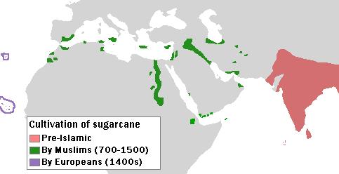 | ৪৮৩ × ২৪৮ (১৬ KB) | smartcommons>File Upload Bot (Magnus Manske) | {{BotMoveToCommons|en.wikipedia|year={{subst:CURRENTYEAR}}|month={{subst:CURRENTMONTHNAME}}|day={{subst:CURRENTDAY}}}} {{Information |Description={{en|Author: User:Bless_sins. Source: I saw this map in: Watson, Andrew. ''Agricultural innovation in the ea |
ꯐꯥꯏꯜꯒꯤ ꯁꯤꯖꯤꯟꯅꯐꯝ
ꯃꯁꯤꯒꯤ ꯐꯥꯏꯜ ꯁꯤ ꯁꯤꯖꯤꯟꯅꯕ ꯂꯃꯥꯏꯁꯤꯡ ꯂꯩꯇꯦ ꯫
