Jump to content

ꯐꯥꯏꯜ:Sally Port.jpg

ꯚꯥꯔꯠꯄꯤꯗꯤꯌꯥ ꯗꯒꯤ

ꯐꯥꯏꯜ ꯑꯁꯦꯡꯕ (১,২০০ × ১,১০৩ ꯄꯤꯛꯆꯦꯜꯁ, ꯐꯥꯏꯜ ꯆꯥꯎꯕꯒꯤ ꯆꯥꯡ: ২৪১ KB, MIME ꯃꯈꯜ: image/jpeg)

ꯃꯁꯤꯒꯤ ꯐꯥꯏꯜ ꯑꯁꯤ a shared repository ꯗꯒꯤꯅꯤ ꯑꯃꯁꯨꯡ ꯑꯇꯩ ꯊꯧꯔꯥꯁꯁꯤꯡꯅꯥ ꯁꯤꯖꯤꯟꯅꯩ ꯫ ꯃꯁꯤꯗ ꯁꯟꯗꯣꯛꯅꯥ ꯇꯥꯛꯄ ꯑꯁꯤ ꯐꯥꯏꯜ ꯁꯟꯗꯣꯛꯅꯥ ꯍꯥꯏꯕ ꯂꯃꯥꯏ ꯃꯈꯥꯒꯤ ꯁꯤꯗ ꯎꯨꯠꯂꯦ ꯫

ꯑꯇꯦꯟꯕꯥ ꯁꯟꯗꯣꯛꯅꯥ ꯇꯥꯛꯄꯥ

ꯁꯟꯗꯣꯛꯅꯥ ꯇꯥꯛꯄꯥSally Port.jpg
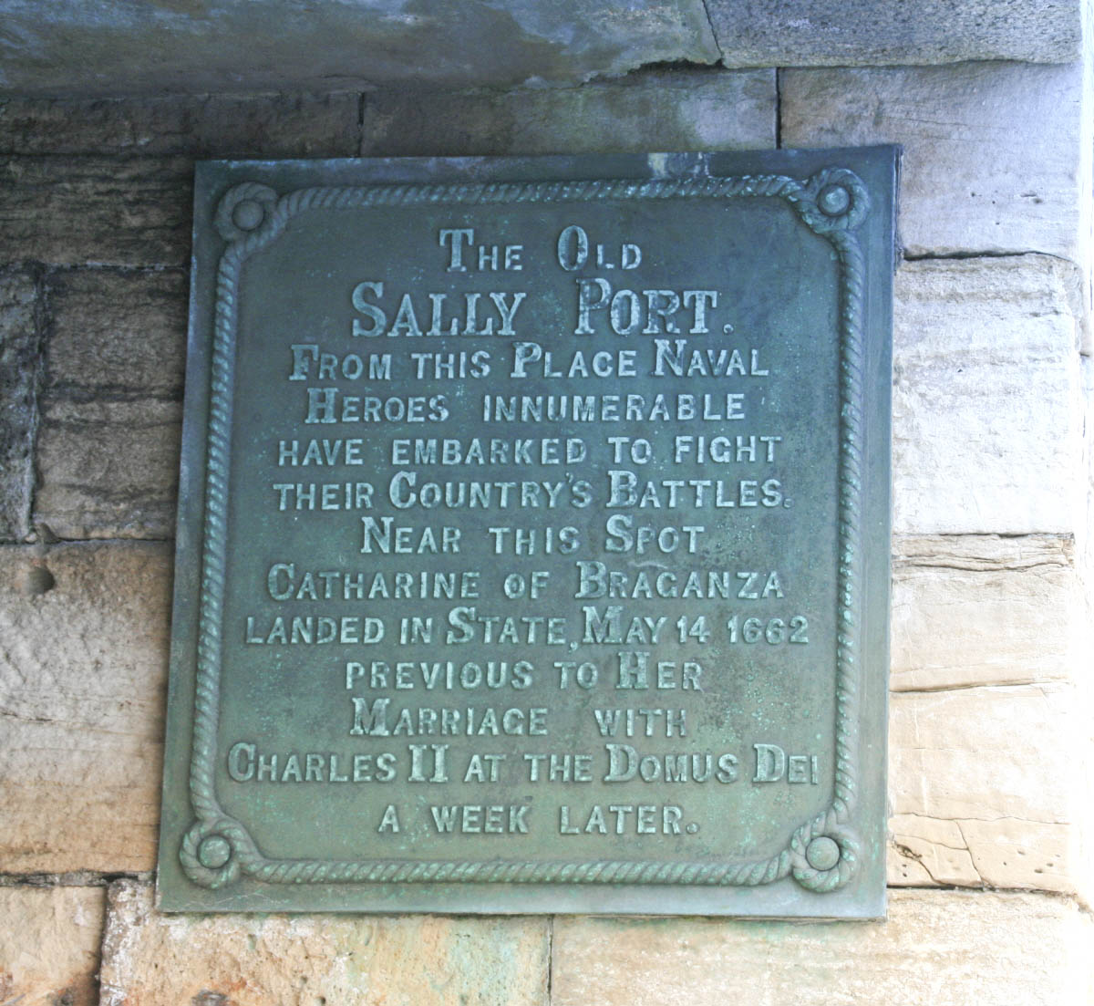
English: The Sally Port adjacent to the Square Tower on the Portsmouth Harbour fortifications. A Sally Port is an opening in the walls where mariners could enter and leave, and from where garrison soldiers could "sally forth" to engage an enemy outside the walls.

This Sally Port is where the bride of King Charles II, Catherine of Braganza disembarked in England on 14 May 1662 for her wedding at Domus Dei nearby, more commonly known now as the Royal Garrison Church of Portsmouth.

Image uploaded by me User:George.Hutchinson from a photograph taken by and supplied by Brian Burnell.

Wikipedia editors are reminded that the copyright remains with the photographer, and that the terms of the Creative Commons licence; that allow editors to reuse this image apply to Wikipedia editors also, as they do to other re-users of this image. Breaches of the licence terms are not only unlawful, but are also antisocial, in that breaches discourage photographers from making their images freely available to everyone without payment. Wikipedia re-users are also reminded of the license terms that derivatives of this image should not imply that the adaptation is endorsed or approved by the author or copyright holder. Neither should derivatives be presented as the creation of the author or copyright holder, while clearly stating that the adaptation is a derivative of the original.

Attribution online should be in this format Brian Burnell. On the printed page, a simpler form is acceptable - example: "Image: Brian Burnell".

Non-Wikipedia users are requested to advise Brian Burnell of its use other than on Wikipedia.
ꯆꯩꯆꯠ
ꯍꯧꯔꯛꯐꯛ ꯏꯁꯥ ꯏꯊꯟꯇꯒꯤ ꯑꯣꯏꯕꯥ ꯊꯕꯛ
ꯄꯨꯊꯣꯛꯂꯤꯕ ꯃꯤ

This image photographed by Brian Burnell with permission was uploaded to Commons by George Hutchinson.
To see his entire portfolio, click here.
Permission to upload photographs by Brian Burnell is archived in the OTRS system as shown below each image.


This image is protected by copyright! If you would like to use it outside Wikipedia, please read THIS first.


© The copyright holder of this file allows anyone to use it for any purpose, provided that the copyright holder is properly attributed. Redistribution, derivative work, commercial use, and all other use is permitted.

Attribution

ꯑꯌꯥꯕ ꯂꯧꯕ
(ꯃꯁꯤꯒꯤ ꯐꯥꯏꯜꯁꯤ ꯑꯃꯨꯛ ꯍꯟꯅꯥ ꯁꯤꯖꯤꯟꯅꯕꯥ)


Camera location৫০° ৪৭′ ২২.৬৮″ N, ১° ০৬′ ২৫.৭২″ W Kartographer map based on OpenStreetMap.View this and other nearby images on: OpenStreetMapinfo 50.789633; -1.107144

ꯑꯌꯥꯕꯥ

I, the copyright holder of this work, hereby publish it under the following licenses:
w:en:Creative Commons
ꯈꯣꯝꯒꯠꯂꯛꯄꯥ ꯃꯥꯟꯅꯕꯥ ꯁꯥꯔꯨꯛ
ꯐꯥꯏꯜ ꯑꯁꯤ ꯀ꯭ꯔꯤꯌꯦꯇꯤꯚ ꯀꯣꯃꯣꯟꯁꯀꯤ Attribution-Share Alike 3.0 Unported ꯑꯌꯥꯕꯒꯤ ꯃꯈꯥꯗ ꯌꯥꯎꯕꯅꯤ ꯫
ꯅꯪꯒꯤ ꯀꯨꯁꯤ:
  • ꯃꯌꯥꯝꯗꯥ ꯐꯪꯍꯟꯕꯥ – ꯊꯥꯕꯛ ꯑꯗꯨ ꯁꯤꯟꯖꯤꯟꯕꯥ, ꯌꯦꯟꯊꯣꯛ ꯎ ꯑꯃꯥꯗꯤ ꯃꯐꯝ ꯱ ꯗꯥ ꯆꯠꯍꯟꯂꯨ
  • ꯑꯃꯨꯛꯀꯥ ꯌꯥꯟꯁꯤꯟꯅꯍꯟꯕꯥ – ꯊꯥꯕꯛꯇꯨꯒꯥ ꯆꯨꯁꯤꯟꯅꯍꯟꯕꯥ
ꯃꯈꯥꯒꯤ ꯌꯥꯅꯕꯒꯤ ꯃꯈꯥ ꯄꯣꯟꯅ:
  • ꯈꯣꯝꯒꯠꯂꯛꯄꯥ – ꯅꯪꯅ ꯆꯞꯆꯥꯕ ꯇꯧꯕꯤꯃꯜ ꯄꯤꯕꯤꯒꯗꯕꯅꯤ, ꯑꯌꯥꯕ ꯄꯤꯔꯤꯕꯁꯤꯡꯒ ꯁꯝꯅꯐꯝ ꯄꯤꯒꯗꯕꯅꯤ ꯑꯃꯁꯨꯡ ꯑꯍꯣꯡꯕ ꯈꯔꯥ ꯂꯩꯔꯗꯤ ꯃꯗꯨ ꯎꯠꯀꯗꯕꯅꯤ ꯫ ꯅꯪꯅ ꯃꯗꯨ ꯃꯔꯝ ꯂꯩꯅ ꯇꯧꯒꯗꯕꯅꯤ, ꯑꯗꯨꯕꯨ ꯑꯌꯥꯕ ꯄꯥꯏꯔꯤꯕꯗꯨꯅ ꯍꯥꯏꯔꯛꯄ ꯃꯑꯣꯡ ꯅꯠꯇ꯭ꯔꯒ ꯅꯪꯅ ꯁꯤꯖꯤꯟꯅꯕ ꯃꯑꯣꯡꯗ ꯇꯧꯔꯣꯏꯗꯕꯅꯤ ꯫
  • ꯃꯥꯟꯅꯕꯥ ꯁꯥꯔꯨꯛ – ꯀꯔꯤꯒꯨꯝꯅ ꯅꯪꯅ ꯌꯥꯟꯁꯤꯟꯅꯔꯕ, ꯍꯣꯡꯗꯣꯛꯍꯟꯂꯕ, ꯅꯠꯇ꯭ꯔꯒ ꯄꯣꯠꯆꯪꯁꯤꯡ ꯁꯥꯒꯠꯂꯕꯗꯤ, ꯅꯪꯒꯤ ꯍꯣꯠꯅꯖꯃꯟ ꯑꯗꯨ ꯃꯁꯤꯒꯤ same or compatible licenseꯒꯤ

ꯃꯈꯥꯗ ꯎꯠꯀꯗꯕꯅꯤ ꯑꯁꯦꯡꯕ ꯑꯅꯧꯕ ꯱ ꯑꯣꯏꯅ ꯂꯧꯗꯨꯅ ꯫
https://creativecommons.org/licenses/by-sa/3.0CC BY-SA 3.0 Creative Commons Attribution-Share Alike 3.0 truetrue
GNU head ꯁꯤꯟꯗꯣꯛꯅꯕ ꯑꯌꯥꯕꯗꯨ ꯄꯤꯔꯦ, ꯌꯦꯟꯊꯣꯛꯎ ꯑꯃꯁꯨꯡ/ꯅꯠꯇ꯭ꯔꯒ ꯃꯑꯣꯡ ꯱ꯗ ꯁꯦꯝꯗꯣꯛꯎ ꯃꯁꯤꯒꯤ ꯐꯥꯏꯜ ꯑꯁꯤ ꯖꯤ•ꯑꯦꯟ•ꯌꯨ ꯃꯃꯜ ꯇꯤꯡꯗꯕ ꯗꯣꯀꯨꯃꯦꯟꯇꯦꯁꯟꯒꯤ ꯑꯌꯥꯕ ꯌꯥꯅꯕꯒꯤ ꯃꯈꯥꯗ, ꯚꯔꯖꯟ ꯱.꯲ ꯅꯠꯇ꯭ꯔꯒ ꯇꯨꯡꯗ ꯂꯥꯛꯀꯗꯕ ꯚꯔꯖꯟ Free Software Foundationꯅ ꯐꯣꯡꯗꯣꯛꯂꯕ; ꯂꯣꯏꯅꯅ ꯈꯦꯠꯅꯕ ꯁꯔꯨꯛꯁꯤꯡ ꯌꯥꯎꯗꯅ, ꯂꯥꯏꯔꯤꯛꯀꯤ ꯃꯃꯥꯡꯒꯤ ꯃꯈꯨꯝ ꯌꯥꯎꯗꯕꯤ, ꯑꯃꯗꯤ ꯂꯥꯏꯔꯤꯛꯀꯤ ꯑꯔꯣꯏꯕ ꯆꯦꯈꯨꯝ ꯌꯥꯎꯗꯕꯤ ꯫ ꯁꯤꯟꯗꯣꯛꯄ ꯌꯥꯕꯒꯤ ꯑꯌꯥꯕꯁꯤꯡꯁꯤ GNU Free Documentation Licenseꯒꯤ ꯁ꯭ꯔꯨꯛꯁꯤꯡꯗ ꯌꯥꯎꯔꯦhttp://www.gnu.org/copyleft/fdl.htmlGFDLGNU Free Documentation Licensetruetrue
ꯅꯪ ꯅꯁꯥꯅꯥ ꯃꯁꯤꯒꯤ ꯑꯌꯥꯕꯁꯤ ꯈꯟꯕꯥ ꯌꯥꯅꯤ ꯫

Captions

Add a one-line explanation of what this file represents

Items portrayed in this file

depicts ꯏꯪꯂꯤꯁ

copyright status ꯏꯪꯂꯤꯁ

copyrighted ꯏꯪꯂꯤꯁ

captured with ꯏꯪꯂꯤꯁ

Canon EOS 400D ꯏꯪꯂꯤꯁ

source of file ꯏꯪꯂꯤꯁ

50°47'22.6774"N, 1°6'25.7166"W

inception ꯏꯪꯂꯤꯁ

꯲꯴ ꯃꯥꯔꯆ 2011

data size ꯏꯪꯂꯤꯁ

246342 byte

height ꯏꯪꯂꯤꯁ

1103 pixel

width ꯏꯪꯂꯤꯁ

1200 pixel

media type ꯏꯪꯂꯤꯁ

image/jpeg

checksum ꯏꯪꯂꯤꯁ

7e942a4b062d36e7dd6d83c474974ac3511fdd5e

exposure time ꯏꯪꯂꯤꯁ

0.0166666666666667 second

f-number ꯏꯪꯂꯤꯁ

11

ISO speed ꯏꯪꯂꯤꯁ

14304

instance of ꯏꯪꯂꯤꯁ

photograph ꯏꯪꯂꯤꯁ

focal length ꯏꯪꯂꯤꯁ

47 millimetre

ꯐꯥꯏꯜꯒꯤ ꯄꯨꯋꯥꯔꯤ

ꯆꯩꯆꯠ/ꯃꯇꯝꯗ ꯅꯝꯃꯨ ꯃꯇꯝ ꯑꯗꯨꯗ ꯐꯥꯏꯜ ꯑꯗꯨ ꯎꯅꯕ

ꯆꯩꯆꯠ/ꯃꯇꯝꯈꯨꯠꯄꯤꯈꯨꯖꯤꯟꯄꯥꯛ ꯆꯥꯎꯕꯥꯁꯤꯖꯤꯟꯅꯔꯤꯕꯑꯄꯥꯝꯕ ꯐꯣꯡꯗꯣꯛ ꯎ
ꯍꯧꯖꯤꯛꯀꯤ꯲꯰:꯱꯸, ꯲꯹ ꯃꯥꯔꯆ ꯲꯰꯱꯱꯲꯰:꯱꯸, ꯲꯹ ꯃꯥꯔꯆ ꯲꯰꯱꯱ꯒꯤ ꯃꯇꯨꯡ ꯏꯟꯅ ꯊꯝꯅꯦꯜ ꯚꯔꯖꯟ১,২০০ × ১,১০৩ (২৪১ KB)smartcommons>George.Hutchinson{{Information |Description ={{en|1=The Sally Port adjacent to the Square Tower on the Portsmouth Harbour fortifications. A Sally Port is an opening in the walls where mariners could enter and leave, and from where garrison soldiers could "sally forth"

ꯃꯁꯤꯒꯤ ꯐꯥꯏꯜ ꯁꯤ ꯁꯤꯖꯤꯟꯅꯕ ꯂꯃꯥꯏꯁꯤꯡ ꯂꯩꯇꯦ ꯫

"https://mni.bharatpedia.org/wiki/ꯐꯥꯏꯜ:Sally_Port.jpg" ꯃꯐꯝꯗꯨꯗꯒꯤ ꯂꯧꯈꯠꯂꯛꯄꯥ