ꯐꯥꯏꯜ:Ottoman Empire Administrative Divisions.png
ꯐꯥꯏꯜ ꯑꯁꯦꯡꯕ (৪,৪৫৫ × ৪,৮৪০ ꯄꯤꯛꯆꯦꯜꯁ, ꯐꯥꯏꯜ ꯆꯥꯎꯕꯒꯤ ꯆꯥꯡ: ২.১ MB, MIME ꯃꯈꯜ: image/png)

|
This map image could be re-created using vector graphics as a SVG file. This has several advantages; see Commons:Media for cleanup for more information. If a SVG form of this image is available, please upload it and afterwards replace this template with
{{vector version available|new image name}}.It is recommended to name the SVG file “Ottoman Empire Administrative Divisions.svg”—then the template Vector version available (or Vva) does not need the new image name parameter. |
ꯑꯇꯦꯟꯕꯥ ꯁꯟꯗꯣꯛꯅꯥ ꯇꯥꯛꯄꯥ
| ꯁꯟꯗꯣꯛꯅꯥ ꯇꯥꯛꯄꯥOttoman Empire Administrative Divisions.png |
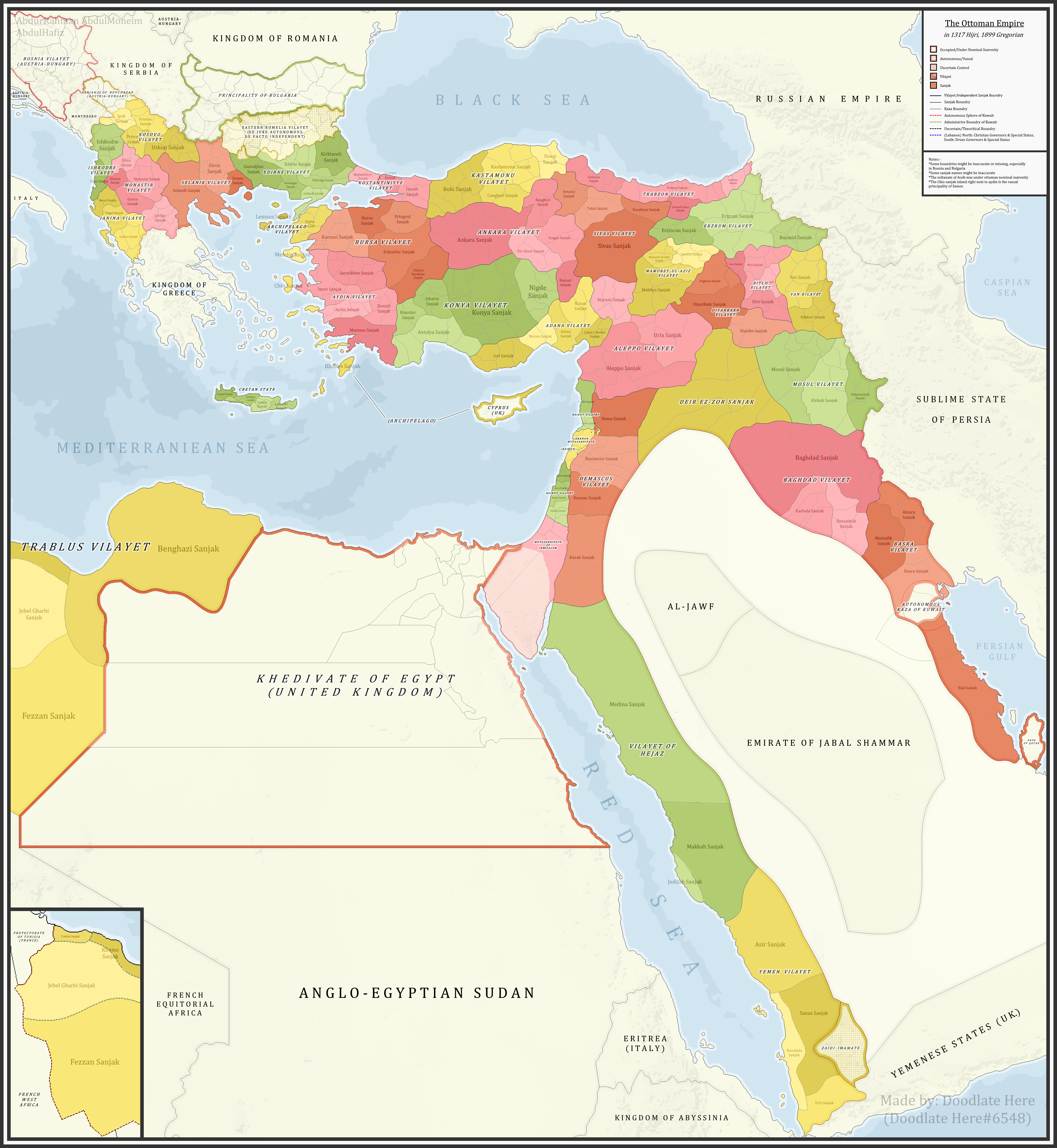
English: A detailed map showing the Ottoman Empire and its dependencies, including its administrative divisions, in 1899 CE (1317 Hijri). |
| ꯆꯩꯆꯠ | |
| ꯍꯧꯔꯛꯐꯛ |
ꯏꯁꯥ ꯏꯊꯟꯇꯒꯤ ꯑꯣꯏꯕꯥ ꯊꯕꯛ References:The sources that back up the maps are as follows: [1] Pavet de Courteille, Abel (1876). État présent de l'empire ottoman (in French). J. Dumaine. pp. 91–96. (for Yemen) [2] http://tarihvemedeniyet.org/2009/10/trablus-garb-vilayeti.html for Tripolitania [3] http://tarihvemedeniyet.org/2009/10/bosna-vilayeti.html for Bosnia [4] https://www.nsi.bg/nrnm/index.php?i=1&ezik=en for eastern Rumelia [5] http://hdl.loc.gov/loc.gmd/g7431f.ct002181 (Rest of Ottoman subdivisions, taken from the United States Library of Congress's Geography & Map Division, digital ID g7431f.ct002181) |
| ꯄꯨꯊꯣꯛꯂꯤꯕ ꯃꯤ | AbdurRahman AbdulMoneim |
| Other versions |



ꯑꯌꯥꯕꯥ


- ꯅꯪꯒꯤ ꯀꯨꯁꯤ:
- ꯃꯌꯥꯝꯗꯥ ꯐꯪꯍꯟꯕꯥ – ꯊꯥꯕꯛ ꯑꯗꯨ ꯁꯤꯟꯖꯤꯟꯕꯥ, ꯌꯦꯟꯊꯣꯛ ꯎ ꯑꯃꯥꯗꯤ ꯃꯐꯝ ꯱ ꯗꯥ ꯆꯠꯍꯟꯂꯨ
- ꯑꯃꯨꯛꯀꯥ ꯌꯥꯟꯁꯤꯟꯅꯍꯟꯕꯥ – ꯊꯥꯕꯛꯇꯨꯒꯥ ꯆꯨꯁꯤꯟꯅꯍꯟꯕꯥ
- ꯃꯈꯥꯒꯤ ꯌꯥꯅꯕꯒꯤ ꯃꯈꯥ ꯄꯣꯟꯅ:
- ꯈꯣꯝꯒꯠꯂꯛꯄꯥ – ꯅꯪꯅ ꯆꯞꯆꯥꯕ ꯇꯧꯕꯤꯃꯜ ꯄꯤꯕꯤꯒꯗꯕꯅꯤ, ꯑꯌꯥꯕ ꯄꯤꯔꯤꯕꯁꯤꯡꯒ ꯁꯝꯅꯐꯝ ꯄꯤꯒꯗꯕꯅꯤ ꯑꯃꯁꯨꯡ ꯑꯍꯣꯡꯕ ꯈꯔꯥ ꯂꯩꯔꯗꯤ ꯃꯗꯨ ꯎꯠꯀꯗꯕꯅꯤ ꯫ ꯅꯪꯅ ꯃꯗꯨ ꯃꯔꯝ ꯂꯩꯅ ꯇꯧꯒꯗꯕꯅꯤ, ꯑꯗꯨꯕꯨ ꯑꯌꯥꯕ ꯄꯥꯏꯔꯤꯕꯗꯨꯅ ꯍꯥꯏꯔꯛꯄ ꯃꯑꯣꯡ ꯅꯠꯇ꯭ꯔꯒ ꯅꯪꯅ ꯁꯤꯖꯤꯟꯅꯕ ꯃꯑꯣꯡꯗ ꯇꯧꯔꯣꯏꯗꯕꯅꯤ ꯫
- ꯃꯥꯟꯅꯕꯥ ꯁꯥꯔꯨꯛ – ꯀꯔꯤꯒꯨꯝꯅ ꯅꯪꯅ ꯌꯥꯟꯁꯤꯟꯅꯔꯕ, ꯍꯣꯡꯗꯣꯛꯍꯟꯂꯕ, ꯅꯠꯇ꯭ꯔꯒ ꯄꯣꯠꯆꯪꯁꯤꯡ ꯁꯥꯒꯠꯂꯕꯗꯤ, ꯅꯪꯒꯤ ꯍꯣꯠꯅꯖꯃꯟ ꯑꯗꯨ ꯃꯁꯤꯒꯤ same or compatible licenseꯒꯤ
| Annotations InfoField | This image is annotated: View the annotations at Commons |

The sources that back up the maps are as follows:
[1] Pavet de Courteille, Abel (1876). État présent de l'empire ottoman (in French). J. Dumaine. pp. 91–96. (for Yemen)
[2] http://tarihvemedeniyet.org/2009/10/trablus-garb-vilayeti.html for Tripolitania
[3] http://tarihvemedeniyet.org/2009/10/bosna-vilayeti.html for Bosnia
[4] https://www.nsi.bg/nrnm/index.php?i=1&ezik=en for eastern Rumelia
[5] http://hdl.loc.gov/loc.gmd/g7431f.ct002181 (Rest of Ottoman subdivisions, taken from the United States Library of Congress's Geography & Map Division, digital ID g7431f.ct002181)
Captions
ꯐꯥꯏꯜꯒꯤ ꯄꯨꯋꯥꯔꯤ
ꯆꯩꯆꯠ/ꯃꯇꯝꯗ ꯅꯝꯃꯨ ꯃꯇꯝ ꯑꯗꯨꯗ ꯐꯥꯏꯜ ꯑꯗꯨ ꯎꯅꯕ
| ꯆꯩꯆꯠ/ꯃꯇꯝ | ꯈꯨꯠꯄꯤꯈꯨꯖꯤꯟ | ꯄꯥꯛ ꯆꯥꯎꯕꯥ | ꯁꯤꯖꯤꯟꯅꯔꯤꯕ | ꯑꯄꯥꯝꯕ ꯐꯣꯡꯗꯣꯛ ꯎ | |
|---|---|---|---|---|---|
| ꯍꯧꯖꯤꯛꯀꯤ | ꯱꯲:꯴꯶, ꯱꯶ ꯅꯣꯚꯦꯝꯕꯔ ꯲꯰꯲꯱ | Error creating thumbnail: File with dimensions greater than ১২.৫ MP | ৪,৪৫৫ × ৪,৮৪০ (২.১ MB) | smartcommons>BasilLeaf | updates |
ꯐꯥꯏꯜꯒꯤ ꯁꯤꯖꯤꯟꯅꯐꯝ
ꯃꯁꯤꯒꯤ ꯐꯥꯏꯜ ꯁꯤ ꯁꯤꯖꯤꯟꯅꯕ ꯂꯃꯥꯏꯁꯤꯡ ꯂꯩꯇꯦ ꯫
