Jump to content

ꯐꯥꯏꯜ:Map achaemenid empire en.png

ꯚꯥꯔꯠꯄꯤꯗꯤꯌꯥ ꯗꯒꯤ

ꯐꯥꯏꯜ ꯑꯁꯦꯡꯕ (১,৬৭৬ × ৮৬৯ ꯄꯤꯛꯆꯦꯜꯁ, ꯐꯥꯏꯜ ꯆꯥꯎꯕꯒꯤ ꯆꯥꯡ: ৩৭৬ KB, MIME ꯃꯈꯜ: image/png)

ꯃꯁꯤꯒꯤ ꯐꯥꯏꯜ ꯑꯁꯤ a shared repository ꯗꯒꯤꯅꯤ ꯑꯃꯁꯨꯡ ꯑꯇꯩ ꯊꯧꯔꯥꯁꯁꯤꯡꯅꯥ ꯁꯤꯖꯤꯟꯅꯩ ꯫ ꯃꯁꯤꯗ ꯁꯟꯗꯣꯛꯅꯥ ꯇꯥꯛꯄ ꯑꯁꯤ ꯐꯥꯏꯜ ꯁꯟꯗꯣꯛꯅꯥ ꯍꯥꯏꯕ ꯂꯃꯥꯏ ꯃꯈꯥꯒꯤ ꯁꯤꯗ ꯎꯨꯠꯂꯦ ꯫

ꯑꯇꯦꯟꯕꯥ ꯁꯟꯗꯣꯛꯅꯥ ꯇꯥꯛꯄꯥ

ꯁꯟꯗꯣꯛꯅꯥ ꯇꯥꯛꯄꯥMap achaemenid empire en.png
ꯆꯩꯆꯠ ꯳꯱ ꯑꯒꯁ ꯲꯰꯰꯶ (original upload date)
ꯍꯧꯔꯛꯐꯛ ꯏꯁꯥ ꯏꯊꯟꯇꯒꯤ ꯑꯣꯏꯕꯥ ꯊꯕꯛ
ꯄꯨꯊꯣꯛꯂꯤꯕ ꯃꯤ Fabienkhan
Other versions
This historical map image could be re-created using vector graphics as a SVG file. This has several advantages; see Commons:Media for cleanup for more information. If a SVG form of this image is available, please upload it and afterwards replace this template with {{vector version available|new image name}}.
It is recommended to name the SVG file “Map achaemenid empire en.svg”—then the template Vector version available (or Vva) does not need the new image name parameter.
[ꯁꯦꯝꯒꯠ ꯁꯥꯒꯠꯂꯨ]

ꯑꯌꯥꯕꯥ

I, the copyright holder of this work, hereby publish it under the following license:
w:en:Creative Commons
ꯈꯣꯝꯒꯠꯂꯛꯄꯥ ꯃꯥꯟꯅꯕꯥ ꯁꯥꯔꯨꯛ
This file is licensed under the Creative Commons Attribution-Share Alike 2.5 Generic, 2.0 Generic and 1.0 Generic license.
ꯅꯪꯒꯤ ꯀꯨꯁꯤ:
  • ꯃꯌꯥꯝꯗꯥ ꯐꯪꯍꯟꯕꯥ – ꯊꯥꯕꯛ ꯑꯗꯨ ꯁꯤꯟꯖꯤꯟꯕꯥ, ꯌꯦꯟꯊꯣꯛ ꯎ ꯑꯃꯥꯗꯤ ꯃꯐꯝ ꯱ ꯗꯥ ꯆꯠꯍꯟꯂꯨ
  • ꯑꯃꯨꯛꯀꯥ ꯌꯥꯟꯁꯤꯟꯅꯍꯟꯕꯥ – ꯊꯥꯕꯛꯇꯨꯒꯥ ꯆꯨꯁꯤꯟꯅꯍꯟꯕꯥ
ꯃꯈꯥꯒꯤ ꯌꯥꯅꯕꯒꯤ ꯃꯈꯥ ꯄꯣꯟꯅ:
  • ꯈꯣꯝꯒꯠꯂꯛꯄꯥ – ꯅꯪꯅ ꯆꯞꯆꯥꯕ ꯇꯧꯕꯤꯃꯜ ꯄꯤꯕꯤꯒꯗꯕꯅꯤ, ꯑꯌꯥꯕ ꯄꯤꯔꯤꯕꯁꯤꯡꯒ ꯁꯝꯅꯐꯝ ꯄꯤꯒꯗꯕꯅꯤ ꯑꯃꯁꯨꯡ ꯑꯍꯣꯡꯕ ꯈꯔꯥ ꯂꯩꯔꯗꯤ ꯃꯗꯨ ꯎꯠꯀꯗꯕꯅꯤ ꯫ ꯅꯪꯅ ꯃꯗꯨ ꯃꯔꯝ ꯂꯩꯅ ꯇꯧꯒꯗꯕꯅꯤ, ꯑꯗꯨꯕꯨ ꯑꯌꯥꯕ ꯄꯥꯏꯔꯤꯕꯗꯨꯅ ꯍꯥꯏꯔꯛꯄ ꯃꯑꯣꯡ ꯅꯠꯇ꯭ꯔꯒ ꯅꯪꯅ ꯁꯤꯖꯤꯟꯅꯕ ꯃꯑꯣꯡꯗ ꯇꯧꯔꯣꯏꯗꯕꯅꯤ ꯫
  • ꯃꯥꯟꯅꯕꯥ ꯁꯥꯔꯨꯛ – ꯀꯔꯤꯒꯨꯝꯅ ꯅꯪꯅ ꯌꯥꯟꯁꯤꯟꯅꯔꯕ, ꯍꯣꯡꯗꯣꯛꯍꯟꯂꯕ, ꯅꯠꯇ꯭ꯔꯒ ꯄꯣꯠꯆꯪꯁꯤꯡ ꯁꯥꯒꯠꯂꯕꯗꯤ, ꯅꯪꯒꯤ ꯍꯣꯠꯅꯖꯃꯟ ꯑꯗꯨ ꯃꯁꯤꯒꯤ same or compatible licenseꯒꯤ
ꯃꯈꯥꯗ ꯎꯠꯀꯗꯕꯅꯤ ꯑꯁꯦꯡꯕ ꯑꯅꯧꯕ ꯱ ꯑꯣꯏꯅ ꯂꯧꯗꯨꯅ ꯫
https://creativecommons.org/licenses/by-sa/2.5CC BY-SA 2.5 Creative Commons Attribution-Share Alike 2.5 truetrue

Note :
Inspired by Historical Atlas of Georges Duby (p.11, map D), this map was made by Fabienkhan the 24th of August 2006, using Inkscape and GIMP. Arad translated the map to help.
Inspiré par l'Atlas historique de Georges Duby (Page 11, carte D), cette carte à été conçue par Fabienkhan le 24 août 2006 à l'aide d'Inkscape et de GIMP. Arad a traduit les légendes.
Den här kartan gjordes den 24 augusti 2006 av Fabienkhan med hjälp av Inkscape och GIMP. Arad översatte från det franska originalet. Kartan är inspirerad av Georges Dubys Atlas historique (s.11, karta D).

Description :
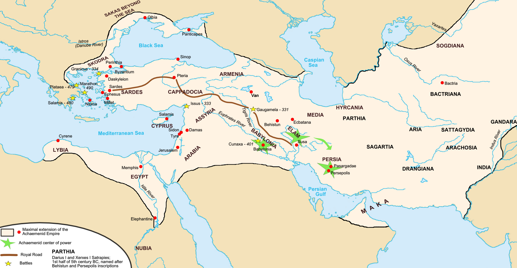
Achaemenid Empire at its maximum extent
Extension maximale de l'empire Achéménide
Akemenidiska riket vid dess största utbredning.

See also French version: Image:Carte empire achéménide.png See also Hungarian svg version: image:Map achaemenid empire hu.svg

Captions

Add a one-line explanation of what this file represents
Территория Персидской империи

Items portrayed in this file

depicts ꯏꯪꯂꯤꯁ

creator ꯏꯪꯂꯤꯁ

copyright status ꯏꯪꯂꯤꯁ

copyrighted ꯏꯪꯂꯤꯁ

source of file ꯏꯪꯂꯤꯁ

ꯐꯥꯏꯜꯒꯤ ꯄꯨꯋꯥꯔꯤ

ꯆꯩꯆꯠ/ꯃꯇꯝꯗ ꯅꯝꯃꯨ ꯃꯇꯝ ꯑꯗꯨꯗ ꯐꯥꯏꯜ ꯑꯗꯨ ꯎꯅꯕ

ꯆꯩꯆꯠ/ꯃꯇꯝꯈꯨꯠꯄꯤꯈꯨꯖꯤꯟꯄꯥꯛ ꯆꯥꯎꯕꯥꯁꯤꯖꯤꯟꯅꯔꯤꯕꯑꯄꯥꯝꯕ ꯐꯣꯡꯗꯣꯛ ꯎ
ꯍꯧꯖꯤꯛꯀꯤ꯱꯰:꯰꯵, ꯱꯹ ꯅꯣꯚꯦꯝꯕꯔ ꯲꯰꯱꯷꯱꯰:꯰꯵, ꯱꯹ ꯅꯣꯚꯦꯝꯕꯔ ꯲꯰꯱꯷ꯒꯤ ꯃꯇꯨꯡ ꯏꯟꯅ ꯊꯝꯅꯦꯜ ꯚꯔꯖꯟ১,৬৭৬ × ৮৬৯ (৩৭৬ KB)smartcommons>R9tgokunksReverted to version as of 00:35, 14 October 2015 (UTC)

ꯃꯁꯤꯒꯤ ꯐꯥꯏꯜ ꯁꯤ ꯁꯤꯖꯤꯟꯅꯕ ꯂꯃꯥꯏꯁꯤꯡ ꯂꯩꯇꯦ ꯫

"https://mni.bharatpedia.org/wiki/ꯐꯥꯏꯜ:Map_achaemenid_empire_en.png" ꯃꯐꯝꯗꯨꯗꯒꯤ ꯂꯧꯈꯠꯂꯛꯄꯥ