ꯐꯥꯏꯜ:Major River Systems within the Mississippi River Basin.svg

Size of this PNG preview of this SVG file: ২২০ × ১৫৫ ꯄꯤꯛꯆꯦꯜꯁ. ꯑꯇꯩ ꯔꯤꯁꯣꯂꯨꯁꯟ: ৩২০ × ২২৫ ꯄꯤꯛꯆꯦꯜꯁ.
ꯐꯥꯏꯜ ꯑꯁꯦꯡꯕ (ꯑꯦꯁ•ꯚꯤ•ꯖꯤ ꯐꯥꯏꯜ, ꯌꯥꯝꯗꯅ ৯৪৫ × ৬৬৪ ꯄꯤꯛꯆꯦꯜ, ꯐꯥꯏꯜ ꯆꯥꯎꯕꯒꯤ ꯆꯥꯡ: ৪৭৩ KB)

ꯑꯇꯦꯟꯕꯥ ꯁꯟꯗꯣꯛꯅꯥ ꯇꯥꯛꯄꯥ
| ꯁꯟꯗꯣꯛꯅꯥ ꯇꯥꯛꯄꯥMajor River Systems within the Mississippi River Basin.svg |
English: Map of the major river systems within the Mississippi River Basin. |
| ꯆꯩꯆꯠ | |
| ꯍꯧꯔꯛꯐꯛ | http://www.epa.gov/msbasin/subbasins/ |
| ꯄꯨꯊꯣꯛꯂꯤꯕ ꯃꯤ | Environmental Protection Agency |
ꯑꯌꯥꯕꯥ
| Public domainPublic domainfalsefalse |
 |
This image (or other media) is a work of an Environmental Protection Agency employee, taken or made as part of that person's official duties. As works of the U.S. federal government, all EPA images are in the public domain.
|
 |
Captions
Add a one-line explanation of what this file represents
ꯐꯥꯏꯜꯒꯤ ꯄꯨꯋꯥꯔꯤ
ꯆꯩꯆꯠ/ꯃꯇꯝꯗ ꯅꯝꯃꯨ ꯃꯇꯝ ꯑꯗꯨꯗ ꯐꯥꯏꯜ ꯑꯗꯨ ꯎꯅꯕ
| ꯆꯩꯆꯠ/ꯃꯇꯝ | ꯈꯨꯠꯄꯤꯈꯨꯖꯤꯟ | ꯄꯥꯛ ꯆꯥꯎꯕꯥ | ꯁꯤꯖꯤꯟꯅꯔꯤꯕ | ꯑꯄꯥꯝꯕ ꯐꯣꯡꯗꯣꯛ ꯎ | |
|---|---|---|---|---|---|
| ꯍꯧꯖꯤꯛꯀꯤ | ꯰꯸:꯳꯴, ꯲꯴ ꯖꯨꯂꯥꯏ ꯲꯰꯲꯳ | 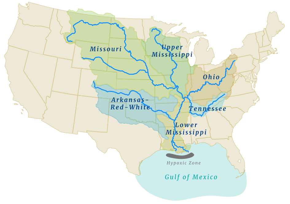 | ৯৪৫ × ৬৬৪ (৪৭৩ KB) | smartcommons>Aaron1a12 | Uploaded a work by Environmental Protection Agency from http://www.epa.gov/msbasin/subbasins/ with UploadWizard |
ꯐꯥꯏꯜꯒꯤ ꯁꯤꯖꯤꯟꯅꯐꯝ
ꯃꯁꯤꯒꯤ ꯐꯥꯏꯜ ꯁꯤ ꯁꯤꯖꯤꯟꯅꯕ ꯂꯃꯥꯏꯁꯤꯡ ꯂꯩꯇꯦ ꯫
