ꯐꯥꯏꯜ:Indonesia Mangrove Distribution.png

ꯃꯁꯤꯒꯤ ꯄ꯭ꯔꯚꯤꯌꯨ ꯑꯁꯤꯒꯤ ꯁꯥꯏꯓ: ২২০ × ১৩২ ꯄꯤꯛꯆꯦꯜꯁ. ꯑꯇꯩ ꯁꯦꯡꯅ ꯌꯦꯡꯕ ꯌꯥꯕ: ৩২০ × ১৯২ ꯄꯤꯛꯆꯦꯜꯁ | ২,৪০০ × ১,৪৩৮ ꯄꯤꯛꯆꯦꯜꯁ.
ꯐꯥꯏꯜ ꯑꯁꯦꯡꯕ (২,৪০০ × ১,৪৩৮ ꯄꯤꯛꯆꯦꯜꯁ, ꯐꯥꯏꯜ ꯆꯥꯎꯕꯒꯤ ꯆꯥꯡ: ৪৩০ KB, MIME ꯃꯈꯜ: image/png)

ꯑꯇꯦꯟꯕꯥ ꯁꯟꯗꯣꯛꯅꯥ ꯇꯥꯛꯄꯥ
| ꯁꯟꯗꯣꯛꯅꯥ ꯇꯥꯛꯄꯥIndonesia Mangrove Distribution.png |
English: Location and relative density of mangroves in South-east Asia and Australasia. Distribution determined using digital image classification techniques which involved compiling and analysing more than 1,000 scenes from the Landsat series of satellites. |
| ꯆꯩꯆꯠ | |
| ꯍꯧꯔꯛꯐꯛ | NASA Earth Observatory |
| ꯄꯨꯊꯣꯛꯂꯤꯕ ꯃꯤ | Jesse Allen |
Data provided by Chandra Giri, U.S. Geological Survey. Instrument: Landsat 5 - TM.
ꯑꯌꯥꯕꯥ
| Public domainPublic domainfalsefalse |

|
This file is in the public domain in the United States because it was solely created by NASA. NASA copyright policy states that "NASA material is not protected by copyright unless noted". (See Template:PD-USGov, NASA copyright policy page or JPL Image Use Policy.) |  |
 |
Warnings:
|

Captions
Add a one-line explanation of what this file represents
ꯐꯥꯏꯜꯒꯤ ꯄꯨꯋꯥꯔꯤ
ꯆꯩꯆꯠ/ꯃꯇꯝꯗ ꯅꯝꯃꯨ ꯃꯇꯝ ꯑꯗꯨꯗ ꯐꯥꯏꯜ ꯑꯗꯨ ꯎꯅꯕ
| ꯆꯩꯆꯠ/ꯃꯇꯝ | ꯈꯨꯠꯄꯤꯈꯨꯖꯤꯟ | ꯄꯥꯛ ꯆꯥꯎꯕꯥ | ꯁꯤꯖꯤꯟꯅꯔꯤꯕ | ꯑꯄꯥꯝꯕ ꯐꯣꯡꯗꯣꯛ ꯎ | |
|---|---|---|---|---|---|
| ꯍꯧꯖꯤꯛꯀꯤ | ꯱꯸:꯱꯲, ꯳꯰ ꯅꯣꯚꯦꯝꯕꯔ ꯲꯰꯱꯰ | 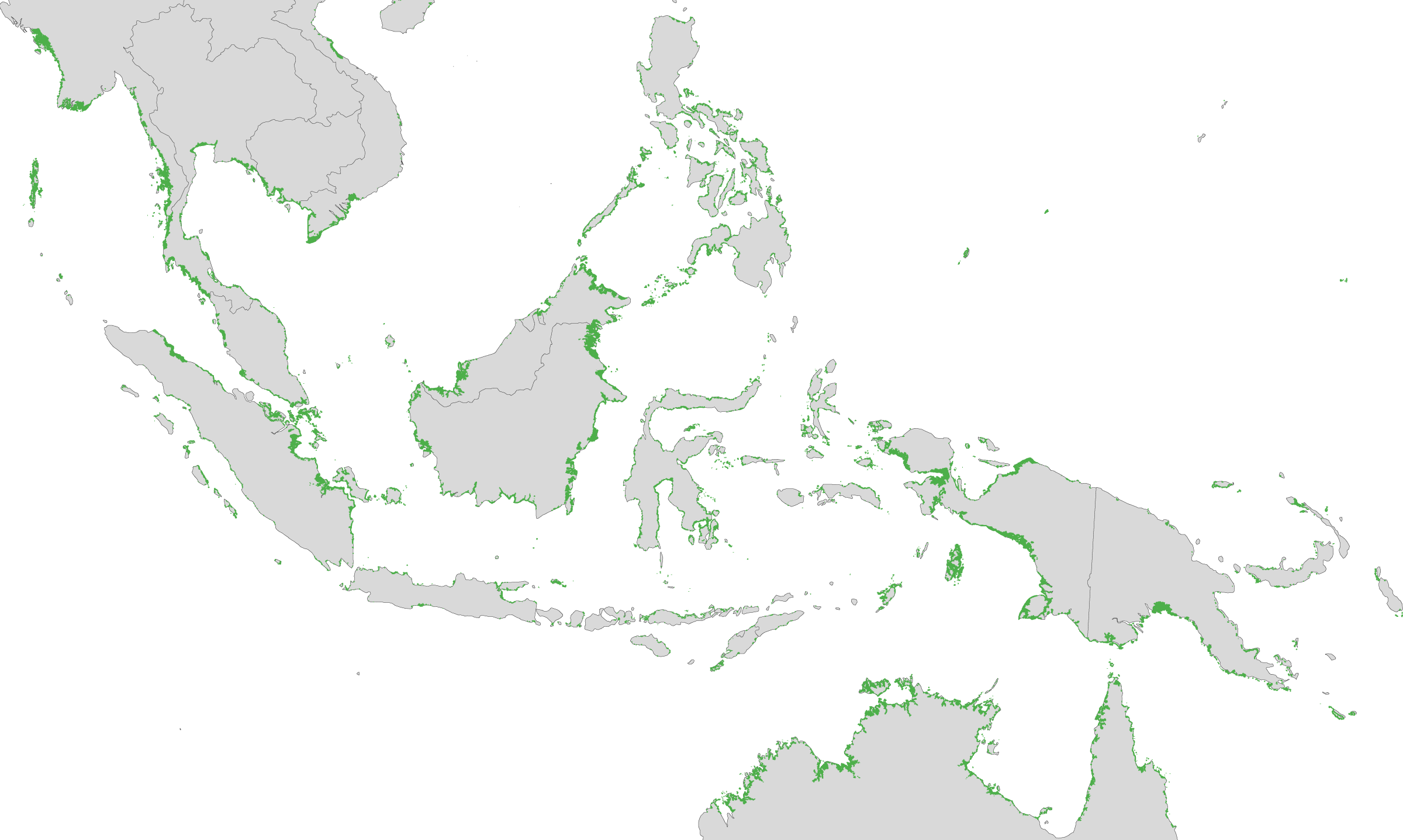 | ২,৪০০ × ১,৪৩৮ (৪৩০ KB) | smartcommons>Originalwana | {{Information |Description={{en|1=Location and relative density of mangroves in Indonesia.}} |Source=[http://earthobservatory.nasa.gov/IOTD/view.php?id=47427 NASA Earth Observatory] |Author=Jesse Allen |Date=2010-11-30 |Permission= | |
ꯐꯥꯏꯜꯒꯤ ꯁꯤꯖꯤꯟꯅꯐꯝ
ꯃꯁꯤꯒꯤ ꯐꯥꯏꯜ ꯁꯤ ꯁꯤꯖꯤꯟꯅꯕ ꯂꯃꯥꯏꯁꯤꯡ ꯂꯩꯇꯦ ꯫
