ꯐꯥꯏꯜ:Greater Israel map.jpg

ꯐꯥꯏꯜ ꯑꯁꯦꯡꯕ (১,১০৯ × ৬৫৬ ꯄꯤꯛꯆꯦꯜꯁ, ꯐꯥꯏꯜ ꯆꯥꯎꯕꯒꯤ ꯆꯥꯡ: ১৫৭ KB, MIME ꯃꯈꯜ: image/jpeg)


ꯑꯇꯦꯟꯕꯥ ꯁꯟꯗꯣꯛꯅꯥ ꯇꯥꯛꯄꯥ
NOTE: The interpretation of the phrase "River of Egypt" as referring to the Nile is actually somewhat controversial (the standard Biblical Hebrew word for the Nile יאר is not used in the Genesis 15 passage), while the Euphrates was probably meant to refer mainly to Tiphsah in northern Syria.
| ꯁꯟꯗꯣꯛꯅꯥ ꯇꯥꯛꯄꯥGreater Israel map.jpg |
English: Map of en:Greater Israel as defined in Genesis 15:18-21 Genesis 15:18-21 (KJV): In the same day the LORD made a covenant with Abram, saying, Unto thy seed have I given this land, from the river of Egypt unto the great river, the river Euphrates: The Kenites, and the Kenizzites, and the Kadmonites, And the Hittites, and the Perizzites, and the Rephaims, And the Amorites, and the Canaanites, and the Girgashites, and the Jebusites. The Biblical Amorites are considered synonymous with the Canaanites and occupied the same land. InterpretationMy first reference was The International Standard Bible Encyclopedia Online. I also consulted the Jewish Encyclopedia, the Bible Wiki and, of course, Google and Google Images. CommentThis is a JPEG copy of a 1109 x 656 pixel Corel PhotoPaint file. This map is very vague, to reflect the vagueness of this passage. The exact locations of many of these sites is lost forever. This map is therefore the result of speculations by many experts (not me). If you feel strongly about some aspect of it, contact me with references. To preserve the quality of the image, future edits should be done on the original file. This map is to complement my previous map of the Land of Israel as defined in Numbers 34:1-12 and Ezekiel 47:13-20. The resemblance between this map and the map of the Kingdom of Israel at David's death is striking, but the origin and time of these two maps is very different. This map is, heavens forbid, the result of Original Research by myself, and is also an image. Original research is not allowed in Wikipedia, but original images are. The survival of this map to the scrutiny of the NOR police therefore depends on this ambiguity. If you want to publish this map elsewhere, I'll be glad to email you the original file. ꯑꯌꯥꯕꯥ |
| ꯆꯩꯆꯠ |
꯲꯸ ꯃꯥꯔꯆ ꯲꯰꯰꯸ (original upload date) |
| ꯍꯧꯔꯛꯐꯛ | ꯏꯁꯥ ꯏꯊꯟꯇꯒꯤ ꯑꯣꯏꯕꯥ ꯊꯕꯛ (Original text: self-made) |
| ꯄꯨꯊꯣꯛꯂꯤꯕ ꯃꯤ | Emmanuelm (talk) |


ꯑꯌꯥꯕꯥ
| Public domainPublic domainfalsefalse |

|
This work is in the public domain in the United States because it is a work prepared by an officer or employee of the United States Federal Government as part of that person’s official duties under the terms of Title 17, Chapter 1, Section 105 of the US Code.
Note: This only applies to original works of the Federal Government and not to the work of any individual U.S. state, territory, commonwealth, county, municipality, or any other subdivision. This template also does not apply to postage stamp designs published by the United States Postal Service since 1978. (See § 313.6(C)(1) of Compendium of U.S. Copyright Office Practices). It also does not apply to certain US coins; see The US Mint Terms of Use.
|
 |
| This file has been identified as being free of known restrictions under copyright law, including all related and neighboring rights. | ||
https://creativecommons.org/publicdomain/mark/1.0/PDMCreative Commons Public Domain Mark 1.0falsefalse


- ꯅꯪꯒꯤ ꯀꯨꯁꯤ:
- ꯃꯌꯥꯝꯗꯥ ꯐꯪꯍꯟꯕꯥ – ꯊꯥꯕꯛ ꯑꯗꯨ ꯁꯤꯟꯖꯤꯟꯕꯥ, ꯌꯦꯟꯊꯣꯛ ꯎ ꯑꯃꯥꯗꯤ ꯃꯐꯝ ꯱ ꯗꯥ ꯆꯠꯍꯟꯂꯨ
- ꯑꯃꯨꯛꯀꯥ ꯌꯥꯟꯁꯤꯟꯅꯍꯟꯕꯥ – ꯊꯥꯕꯛꯇꯨꯒꯥ ꯆꯨꯁꯤꯟꯅꯍꯟꯕꯥ
- ꯃꯈꯥꯒꯤ ꯌꯥꯅꯕꯒꯤ ꯃꯈꯥ ꯄꯣꯟꯅ:
- ꯈꯣꯝꯒꯠꯂꯛꯄꯥ – ꯅꯪꯅ ꯆꯞꯆꯥꯕ ꯇꯧꯕꯤꯃꯜ ꯄꯤꯕꯤꯒꯗꯕꯅꯤ, ꯑꯌꯥꯕ ꯄꯤꯔꯤꯕꯁꯤꯡꯒ ꯁꯝꯅꯐꯝ ꯄꯤꯒꯗꯕꯅꯤ ꯑꯃꯁꯨꯡ ꯑꯍꯣꯡꯕ ꯈꯔꯥ ꯂꯩꯔꯗꯤ ꯃꯗꯨ ꯎꯠꯀꯗꯕꯅꯤ ꯫ ꯅꯪꯅ ꯃꯗꯨ ꯃꯔꯝ ꯂꯩꯅ ꯇꯧꯒꯗꯕꯅꯤ, ꯑꯗꯨꯕꯨ ꯑꯌꯥꯕ ꯄꯥꯏꯔꯤꯕꯗꯨꯅ ꯍꯥꯏꯔꯛꯄ ꯃꯑꯣꯡ ꯅꯠꯇ꯭ꯔꯒ ꯅꯪꯅ ꯁꯤꯖꯤꯟꯅꯕ ꯃꯑꯣꯡꯗ ꯇꯧꯔꯣꯏꯗꯕꯅꯤ ꯫
Original upload log

- 2008-03-28 19:08 Emmanuelm 1109×656×??? (161042 bytes) {{Information |Description= Map of [[Greater Israel]] as defined in Genesis 15:18-21 |Source=self-made |Date= 2008-03-28 |Location= |Author=~~~ |other_versions= }}
| Annotations InfoField | This image is annotated: View the annotations at Commons |

Mar Rojo
Israel
Captions
ꯐꯥꯏꯜꯒꯤ ꯄꯨꯋꯥꯔꯤ
ꯆꯩꯆꯠ/ꯃꯇꯝꯗ ꯅꯝꯃꯨ ꯃꯇꯝ ꯑꯗꯨꯗ ꯐꯥꯏꯜ ꯑꯗꯨ ꯎꯅꯕ
| ꯆꯩꯆꯠ/ꯃꯇꯝ | ꯈꯨꯠꯄꯤꯈꯨꯖꯤꯟ | ꯄꯥꯛ ꯆꯥꯎꯕꯥ | ꯁꯤꯖꯤꯟꯅꯔꯤꯕ | ꯑꯄꯥꯝꯕ ꯐꯣꯡꯗꯣꯛ ꯎ | |
|---|---|---|---|---|---|
| ꯍꯧꯖꯤꯛꯀꯤ | ꯱꯴:꯰꯷, ꯲꯳ ꯑꯒꯁ ꯲꯰꯰꯸ | 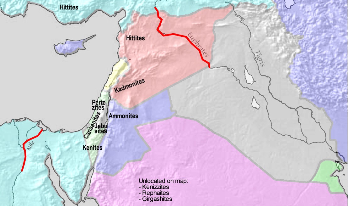 | ১,১০৯ × ৬৫৬ (১৫৭ KB) | smartcommons>Cansado | {{Information |Description={{en|Map of en:Greater Israel as defined in Genesis 15:18-21 '''Genesis 15:18-21 (KJV):''' ''In the same day the LORD made a covenant with Abram, saying, Unto thy seed have I given this land, from the river of Egypt un |
ꯐꯥꯏꯜꯒꯤ ꯁꯤꯖꯤꯟꯅꯐꯝ
ꯃꯁꯤꯒꯤ ꯐꯥꯏꯜ ꯁꯤ ꯁꯤꯖꯤꯟꯅꯕ ꯂꯃꯥꯏꯁꯤꯡ ꯂꯩꯇꯦ ꯫
