ꯐꯥꯏꯜ:Central Provinces India 1903.gif

ꯃꯁꯤꯒꯤ ꯄ꯭ꯔꯚꯤꯌꯨ ꯑꯁꯤꯒꯤ ꯁꯥꯏꯓ: ২২০ × ১৬৫ ꯄꯤꯛꯆꯦꯜꯁ. ꯑꯇꯩ ꯁꯦꯡꯅ ꯌꯦꯡꯕ ꯌꯥꯕ: ৩২০ × ২৪০ ꯄꯤꯛꯆꯦꯜꯁ | ৬৪০ × ৪৮০ ꯄꯤꯛꯆꯦꯜꯁ.
ꯐꯥꯏꯜ ꯑꯁꯦꯡꯕ (৬৪০ × ৪৮০ ꯄꯤꯛꯆꯦꯜꯁ, ꯐꯥꯏꯜ ꯆꯥꯎꯕꯒꯤ ꯆꯥꯡ: ৩৩৬ KB, MIME ꯃꯈꯜ: image/gif)

From map of India by Dodd, Mead and Company, 1903. Library of Congress Geography and Map Collection. Call Number G7650 1903 .D6 TIL
| Public domainPublic domainfalsefalse |
 |
This media file is in the public domain in the United States. This applies to U.S. works where the copyright has expired, often because its first publication occurred prior to January 1, 1931, and if not then due to lack of notice or renewal. See this page for further explanation.
|
 |
 |
Captioned As
| Page | Caption |
|---|---|
| w:History of Nagpur | Central Provinces and Berar, 1903. Princely states are shown in yellow. |
| w:Vidarbha | map of w:Central Provinces and Berar regions of w:British India. Nagpur is shown as capital of Central provinces |
| w:Central Provinces | Central Provinces and Berar in 1903, before the 1905 changes to the eastern boundary. |
| w:Central Provinces and Berar | Central Provinces and Berar, 1903. Princely states are shown in yellow. |
| w:Nagpur | Central Provinces and Berar, 1903. Princely states are shown in yellow. |
Captions
Add a one-line explanation of what this file represents
ꯐꯥꯏꯜꯒꯤ ꯄꯨꯋꯥꯔꯤ
ꯆꯩꯆꯠ/ꯃꯇꯝꯗ ꯅꯝꯃꯨ ꯃꯇꯝ ꯑꯗꯨꯗ ꯐꯥꯏꯜ ꯑꯗꯨ ꯎꯅꯕ
| ꯆꯩꯆꯠ/ꯃꯇꯝ | ꯈꯨꯠꯄꯤꯈꯨꯖꯤꯟ | ꯄꯥꯛ ꯆꯥꯎꯕꯥ | ꯁꯤꯖꯤꯟꯅꯔꯤꯕ | ꯑꯄꯥꯝꯕ ꯐꯣꯡꯗꯣꯛ ꯎ | |
|---|---|---|---|---|---|
| ꯍꯧꯖꯤꯛꯀꯤ | ꯰꯷:꯲꯴, ꯱꯶ ꯁꯦꯞꯇꯦꯝꯕꯔ ꯲꯰꯰꯴ | 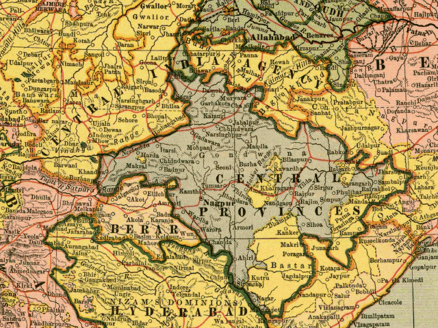 | ৬৪০ × ৪৮০ (৩৩৬ KB) | smartcommons>Tom Radulovich | From map of India by Dodd, Mead and Company, 1903. Library of Congress Geography and Map Collection. {{PD}} |
ꯐꯥꯏꯜꯒꯤ ꯁꯤꯖꯤꯟꯅꯐꯝ
ꯃꯁꯤꯒꯤ ꯐꯥꯏꯜ ꯁꯤ ꯁꯤꯖꯤꯟꯅꯕ ꯂꯃꯥꯏꯁꯤꯡ ꯂꯩꯇꯦ ꯫
