ꯐꯥꯏꯜ:British Indian Empire 1909 Imperial Gazetteer of India.jpg

ꯃꯁꯤꯒꯤ ꯄ꯭ꯔꯚꯤꯌꯨ ꯑꯁꯤꯒꯤ ꯁꯥꯏꯓ: ২২০ × ১৮০ ꯄꯤꯛꯆꯦꯜꯁ. ꯑꯇꯩ ꯁꯦꯡꯅ ꯌꯦꯡꯕ ꯌꯥꯕ: ২৯৪ × ২৪০ ꯄꯤꯛꯆꯦꯜꯁ | ১,৪৯৮ × ১,২২৩ ꯄꯤꯛꯆꯦꯜꯁ.
ꯐꯥꯏꯜ ꯑꯁꯦꯡꯕ (১,৪৯৮ × ১,২২৩ ꯄꯤꯛꯆꯦꯜꯁ, ꯐꯥꯏꯜ ꯆꯥꯎꯕꯒꯤ ꯆꯥꯡ: ৯৫৭ KB, MIME ꯃꯈꯜ: image/jpeg)

ꯑꯇꯦꯟꯕꯥ ꯁꯟꯗꯣꯛꯅꯥ ꯇꯥꯛꯄꯥ
| ꯁꯟꯗꯣꯛꯅꯥ ꯇꯥꯛꯄꯥBritish Indian Empire 1909 Imperial Gazetteer of India.jpg |
English: Map of the British Indian Empire from Imperial Gazetteer of India |
| ꯆꯩꯆꯠ | |
| ꯍꯧꯔꯛꯐꯛ |
Oxford University Press, 1909. Scanned and reduced from personal copy by Fowler&fowler«Talk» 18:10, 5 August 2007 (UTC) |
| ꯄꯨꯊꯣꯛꯂꯤꯕ ꯃꯤ | Edinburgh Geographical Institute; J. G. Bartholomew and Sons. |
ꯑꯌꯥꯕꯥ
| Public domainPublic domainfalsefalse |

|
This work created by the United Kingdom Government is in the public domain.
This is because it is one of the following:
HMSO has declared that the expiry of Crown Copyrights applies worldwide (ref: HMSO Email Reply)
|
 |
Original upload log
Transferred from en.wikipedia to Commons by Trengarasu using CommonsHelper.
The original description page was here. All following user names refer to en.wikipedia.

- 2007-08-05 18:10 Fowler&fowler 1498×1223× (467834 bytes) Image of map of the British Indian Empire from Imperial Gazetteer of India, Oxford University Press, 1909. Scanned and reduced from personal copy by ~~~~ {{PD-old-70}}
Original upload log
| date/time | username | resolution | size | edit summary |
|---|---|---|---|---|
| 2008-10-13T06:26:21Z | User:File Upload Bot (Magnus Manske) | 1498×1223 | 456.87Kb | Description={{en|Image of map of the British Indian Empire from Imperial Gazetteer of India, Oxford University Press, 1909. Scanned and reduced from personal copy by [[:en:User:Fowler&fowler|<span style="co</nowiki"> |
Captions
Add a one-line explanation of what this file represents
Map of the political divisions of the Indian Empire in 1909, showing British India in two shades of pink and Princely States in yellow
இந்திய பிரிவினை
ब्रिटिश इंडियन एम्पायर चा मॅप
برطانوی ہندوستانیۍسلطنتک نقشہ
برطانوی ہندوستانی سلطنت کا نقشہ
Brits-Indiase Rijk in 1909
En 1909, carte de l'Empire indien britannique, montrant l'Inde britannique en deux tons de rose et les États princiers en jaune.
1909 में, ब्रिटिश भारतीय साम्राज्य का नक्शा, ब्रिटिश भारत को गुलाबी रंग से और पीले रंग में रियासतों को दर्शाता है
1909 માં બ્રિટીશ ભારતીય સામ્રાજ્યનો નકશો, બ્રિટીશ ભારતને ગુલાબી રંગ અને રજવાડાઓને પીળો રંગ બતાવવામાં આવ્યો છે.
১৯০৯ চনত ব্ৰিটিছ চৰকাৰে ব্যৱহাৰ কৰা ভাৰতৰ মানচিত্ৰ
Siyasi bölmələrin xəritəsi 1909-cu ildə Hindistan İmperiyası, İngilisləri göstərir Hindistan çəhrayı və Princely iki çalarlarında Sarı rəngli dövlətlər
ಭಾರತ್
ꯐꯥꯏꯜꯒꯤ ꯄꯨꯋꯥꯔꯤ
ꯆꯩꯆꯠ/ꯃꯇꯝꯗ ꯅꯝꯃꯨ ꯃꯇꯝ ꯑꯗꯨꯗ ꯐꯥꯏꯜ ꯑꯗꯨ ꯎꯅꯕ
| ꯆꯩꯆꯠ/ꯃꯇꯝ | ꯈꯨꯠꯄꯤꯈꯨꯖꯤꯟ | ꯄꯥꯛ ꯆꯥꯎꯕꯥ | ꯁꯤꯖꯤꯟꯅꯔꯤꯕ | ꯑꯄꯥꯝꯕ ꯐꯣꯡꯗꯣꯛ ꯎ | |
|---|---|---|---|---|---|
| ꯍꯧꯖꯤꯛꯀꯤ | ꯰꯱:꯵꯶, ꯱꯶ ꯃꯥꯔꯆ ꯲꯰꯱꯲ | 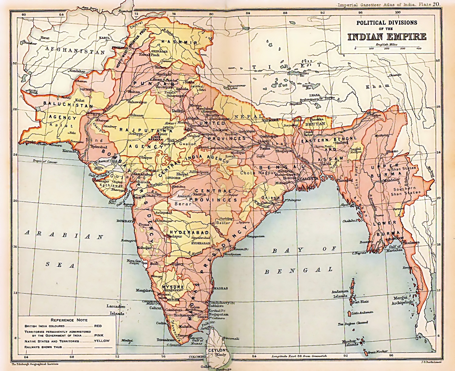 | ১,৪৯৮ × ১,২২৩ (৯৫৭ KB) | smartcommons>Soerfm | Color |
ꯐꯥꯏꯜꯒꯤ ꯁꯤꯖꯤꯟꯅꯐꯝ
ꯃꯁꯤꯒꯤ ꯐꯥꯏꯜ ꯁꯤ ꯁꯤꯖꯤꯟꯅꯕ ꯂꯃꯥꯏꯁꯤꯡ ꯂꯩꯇꯦ ꯫
