ꯐꯥꯏꯜ:Asia 800ad.jpg

ꯃꯁꯤꯒꯤ ꯄ꯭ꯔꯚꯤꯌꯨ ꯑꯁꯤꯒꯤ ꯁꯥꯏꯓ: ২২০ × ১২৭ ꯄꯤꯛꯆꯦꯜꯁ. ꯑꯇꯩ ꯁꯦꯡꯅ ꯌꯦꯡꯕ ꯌꯥꯕ: ৩২০ × ১৮৫ ꯄꯤꯛꯆꯦꯜꯁ | ২,০৯৯ × ১,২১৫ ꯄꯤꯛꯆꯦꯜꯁ.
ꯐꯥꯏꯜ ꯑꯁꯦꯡꯕ (২,০৯৯ × ১,২১৫ ꯄꯤꯛꯆꯦꯜꯁ, ꯐꯥꯏꯜ ꯆꯥꯎꯕꯒꯤ ꯆꯥꯡ: ৮০৯ KB, MIME ꯃꯈꯜ: image/jpeg)

|
This historical map image could be re-created using vector graphics as a SVG file. This has several advantages; see Commons:Media for cleanup for more information. If a SVG form of this image is available, please upload it and afterwards replace this template with
{{vector version available|new image name}}.It is recommended to name the SVG file “Asia 800ad.svg”—then the template Vector version available (or Vva) does not need the new image name parameter. |


ꯑꯇꯦꯟꯕꯥ ꯁꯟꯗꯣꯛꯅꯥ ꯇꯥꯛꯄꯥ
| ꯁꯟꯗꯣꯛꯅꯥ ꯇꯥꯛꯄꯥAsia 800ad.jpg |
English: This image is a zoomed-in version of Image:East-Hem_800ad.jpg (Eastern Hemisphere in 800 AD).
Author: Thomas A. Lessman. Source URL: http://www.ThomasLessman.com/History/images/East-Hem_800ad.jpg. Image was created by me (Thomas Lessman) based on map of Eastern Hemisphere in 800 AD. Image is free for public and/or educational use. I would appreciate a mention if this image is used elsewhere. If anyone is interested in helping further this work, please contact Thomas Lessman at [email protected]. Other Historical Maps by Thomas Lessman
|
| ꯆꯩꯆꯠ | ꯲꯲ ꯑꯣꯛꯇꯣꯕꯔ ꯲꯰꯰꯷ (original upload date); ꯲꯹ ꯖꯥꯅꯨꯋꯥꯔꯤ ꯲꯰꯰꯸ (last version) |
| ꯍꯧꯔꯛꯐꯛ | Transferred from en.wikipedia to Commons by Vinhtantran using CommonsHelper. |
| ꯄꯨꯊꯣꯛꯂꯤꯕ ꯃꯤ | Talessman at ꯏꯪꯂꯤꯁ ꯋꯤꯀꯤꯄꯦꯗꯤꯌꯥ |
| Other versions |
 |


ꯑꯌꯥꯕꯥ
Talessman at ꯏꯪꯂꯤꯁ ꯋꯤꯀꯤꯄꯦꯗꯤꯌꯥ, the copyright holder of this work, hereby publishes it under the following licenses:

|
ꯁꯤꯟꯗꯣꯛꯅꯕ ꯑꯌꯥꯕꯗꯨ ꯄꯤꯔꯦ, ꯌꯦꯟꯊꯣꯛꯎ ꯑꯃꯁꯨꯡ/ꯅꯠꯇ꯭ꯔꯒ ꯃꯑꯣꯡ ꯱ꯗ ꯁꯦꯝꯗꯣꯛꯎ ꯃꯁꯤꯒꯤ ꯐꯥꯏꯜ ꯑꯁꯤ ꯖꯤ•ꯑꯦꯟ•ꯌꯨ ꯃꯃꯜ ꯇꯤꯡꯗꯕ ꯗꯣꯀꯨꯃꯦꯟꯇꯦꯁꯟꯒꯤ ꯑꯌꯥꯕ ꯌꯥꯅꯕꯒꯤ ꯃꯈꯥꯗ, ꯚꯔꯖꯟ ꯱.꯲ ꯅꯠꯇ꯭ꯔꯒ ꯇꯨꯡꯗ ꯂꯥꯛꯀꯗꯕ ꯚꯔꯖꯟ Free Software Foundationꯅ ꯐꯣꯡꯗꯣꯛꯂꯕ; ꯂꯣꯏꯅꯅ ꯈꯦꯠꯅꯕ ꯁꯔꯨꯛꯁꯤꯡ ꯌꯥꯎꯗꯅ, ꯂꯥꯏꯔꯤꯛꯀꯤ ꯃꯃꯥꯡꯒꯤ ꯃꯈꯨꯝ ꯌꯥꯎꯗꯕꯤ, ꯑꯃꯗꯤ ꯂꯥꯏꯔꯤꯛꯀꯤ ꯑꯔꯣꯏꯕ ꯆꯦꯈꯨꯝ ꯌꯥꯎꯗꯕꯤ ꯫ ꯁꯤꯟꯗꯣꯛꯄ ꯌꯥꯕꯒꯤ ꯑꯌꯥꯕꯁꯤꯡꯁꯤ GNU Free Documentation Licenseꯒꯤ ꯁ꯭ꯔꯨꯛꯁꯤꯡꯗ ꯌꯥꯎꯔꯦ ꯫http://www.gnu.org/copyleft/fdl.htmlGFDLGNU Free Documentation Licensetruetrue |


This file is licensed under the Creative Commons Attribution 3.0 Unported license.
ꯈꯣꯝꯒꯠꯂꯛꯄꯥ ꯒꯤ ꯊꯧꯗꯥꯡ:
- ꯅꯪꯒꯤ ꯀꯨꯁꯤ:
- ꯃꯌꯥꯝꯗꯥ ꯐꯪꯍꯟꯕꯥ – ꯊꯥꯕꯛ ꯑꯗꯨ ꯁꯤꯟꯖꯤꯟꯕꯥ, ꯌꯦꯟꯊꯣꯛ ꯎ ꯑꯃꯥꯗꯤ ꯃꯐꯝ ꯱ ꯗꯥ ꯆꯠꯍꯟꯂꯨ
- ꯑꯃꯨꯛꯀꯥ ꯌꯥꯟꯁꯤꯟꯅꯍꯟꯕꯥ – ꯊꯥꯕꯛꯇꯨꯒꯥ ꯆꯨꯁꯤꯟꯅꯍꯟꯕꯥ
- ꯃꯈꯥꯒꯤ ꯌꯥꯅꯕꯒꯤ ꯃꯈꯥ ꯄꯣꯟꯅ:
- ꯈꯣꯝꯒꯠꯂꯛꯄꯥ – ꯅꯪꯅ ꯆꯞꯆꯥꯕ ꯇꯧꯕꯤꯃꯜ ꯄꯤꯕꯤꯒꯗꯕꯅꯤ, ꯑꯌꯥꯕ ꯄꯤꯔꯤꯕꯁꯤꯡꯒ ꯁꯝꯅꯐꯝ ꯄꯤꯒꯗꯕꯅꯤ ꯑꯃꯁꯨꯡ ꯑꯍꯣꯡꯕ ꯈꯔꯥ ꯂꯩꯔꯗꯤ ꯃꯗꯨ ꯎꯠꯀꯗꯕꯅꯤ ꯫ ꯅꯪꯅ ꯃꯗꯨ ꯃꯔꯝ ꯂꯩꯅ ꯇꯧꯒꯗꯕꯅꯤ, ꯑꯗꯨꯕꯨ ꯑꯌꯥꯕ ꯄꯥꯏꯔꯤꯕꯗꯨꯅ ꯍꯥꯏꯔꯛꯄ ꯃꯑꯣꯡ ꯅꯠꯇ꯭ꯔꯒ ꯅꯪꯅ ꯁꯤꯖꯤꯟꯅꯕ ꯃꯑꯣꯡꯗ ꯇꯧꯔꯣꯏꯗꯕꯅꯤ ꯫
ꯅꯪ ꯅꯁꯥꯅꯥ ꯃꯁꯤꯒꯤ ꯑꯌꯥꯕꯁꯤ ꯈꯟꯕꯥ ꯌꯥꯅꯤ ꯫
Original upload log
The original description page was here. All following user names refer to en.wikipedia.

- 2008-01-29 22:50 Talessman 2099×1215×8 (828763 bytes) corrected borders of Tibet and others
- 2007-12-10 23:50 Talessman 2106×1450×8 (911289 bytes) (Correct image uploaded this time; earlier upload was the old version...)
- 2007-12-10 23:48 Talessman 1950×1193×8 (695931 bytes) Uploaded most recently corrected version (as of 12-09-2007)
- 2007-10-31 20:39 Talessman 1950×1193×8 (695931 bytes) Corrected borders of Korea, added info on Far eastern islands
- 2007-10-22 19:15 Talessman 1673×1062×8 (553343 bytes) Author: Thomas A. Lessman. Source URL: http://www.ThomasLessman.com/History/images/East-Hem_800ad.jpg. Image was created by me (Thomas Lessman) based on map of Eastern Hemisphere in 800AD. Image is free for public and/or educational use. I would appreciat
Captions
Add a one-line explanation of what this file represents
Eastern Hemisphere in 800 AD
ꯐꯥꯏꯜꯒꯤ ꯄꯨꯋꯥꯔꯤ
ꯆꯩꯆꯠ/ꯃꯇꯝꯗ ꯅꯝꯃꯨ ꯃꯇꯝ ꯑꯗꯨꯗ ꯐꯥꯏꯜ ꯑꯗꯨ ꯎꯅꯕ
| ꯆꯩꯆꯠ/ꯃꯇꯝ | ꯈꯨꯠꯄꯤꯈꯨꯖꯤꯟ | ꯄꯥꯛ ꯆꯥꯎꯕꯥ | ꯁꯤꯖꯤꯟꯅꯔꯤꯕ | ꯑꯄꯥꯝꯕ ꯐꯣꯡꯗꯣꯛ ꯎ | |
|---|---|---|---|---|---|
| ꯍꯧꯖꯤꯛꯀꯤ | ꯱꯰:꯱꯶, ꯲꯳ ꯖꯨꯟ ꯲꯰꯰꯸ | 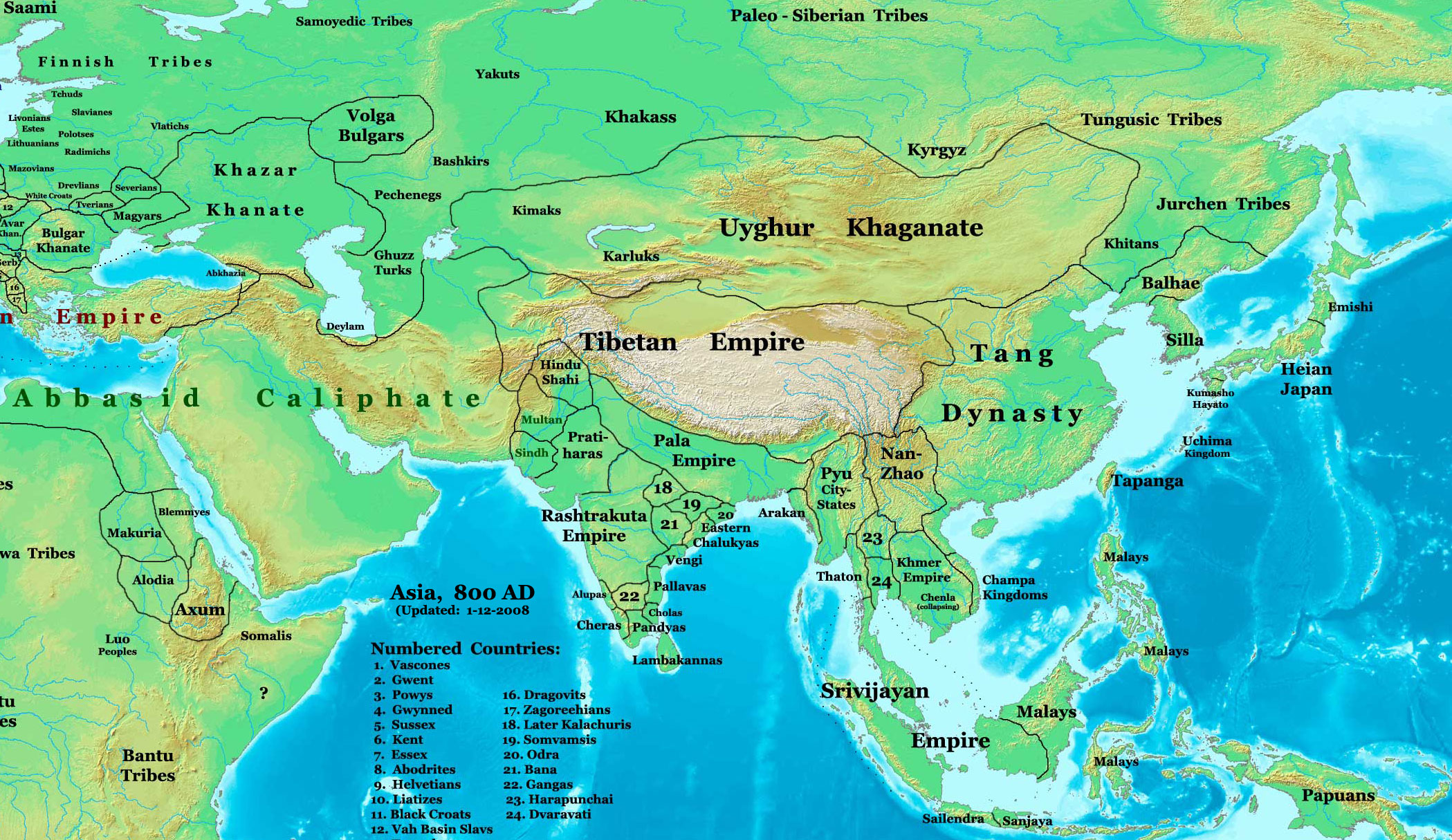 | ২,০৯৯ × ১,২১৫ (৮০৯ KB) | smartcommons>File Upload Bot (Magnus Manske) | {{BotMoveToCommons|en.wikipedia}} {{Information |Description={{en|This image is a zoomed-in version of [http://en.wikipedia.org/wiki/Image:East-Hem_800ad.jpg Eastern Hemisphere in 800 AD]. [[:en:Image:East-Hem_800ad.jpg|thumb|300px|left|Eastern Hemispher |
ꯐꯥꯏꯜꯒꯤ ꯁꯤꯖꯤꯟꯅꯐꯝ
ꯃꯁꯤꯒꯤ ꯐꯥꯏꯜ ꯁꯤ ꯁꯤꯖꯤꯟꯅꯕ ꯂꯃꯥꯏꯁꯤꯡ ꯂꯩꯇꯦ ꯫
