ꯐꯥꯏꯜ:March71.PNG

Size of this preview: ২২০ × ২৮৭ pixels. Other resolutions: ১৮৪ × ২৪০ pixels | ৯১৪ × ১,১৯৪ pixels.

Original file (৯১৪ × ১,১৯৪ pixels, file size: ১৭৯ KB, MIME type: image/png)

Summary
| DescriptionMarch71.PNG |
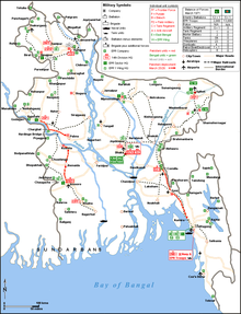
English: This map is a partial representation of Pakistani and Bengali forcese in Bangladesh in March 71. Sources of information are listed in the "Operation Searchlight" article bibliography. The source map was created by user Miljoshi on January 5, 2006 as "Map Bangladesh RoadRail.png" and released under GNU Free documentation license and Creative commons licenses 2.5,2.0 and 1.0. |
| Date | |
| Source |
Transferred from en.wikipedia to Commons.; transfer was stated to be made by Tanvir Rahman. |
| Author | Maglorbd (talk) |
Licensing
Maglorbd at English Wikipedia, the copyright holder of this work, hereby publishes it under the following licenses:


This file is licensed under the Creative Commons Attribution-Share Alike 3.0 Unported license.
Attribution:
- You are free:
- to share – to copy, distribute and transmit the work
- to remix – to adapt the work
- Under the following conditions:
- attribution – You must give appropriate credit, provide a link to the license, and indicate if changes were made. You may do so in any reasonable manner, but not in any way that suggests the licensor endorses you or your use.
- share alike – If you remix, transform, or build upon the material, you must distribute your contributions under the same or compatible license as the original.

|
Permission is granted to copy, distribute and/or modify this document under the terms of the GNU Free Documentation License, Version 1.2 or any later version published by the Free Software Foundation; with no Invariant Sections, no Front-Cover Texts, and no Back-Cover Texts. A copy of the license is included in the section entitled GNU Free Documentation License.http://www.gnu.org/copyleft/fdl.htmlGFDLGNU Free Documentation Licensetruetrue |
You may select the license of your choice.
Original upload log
The original description page was here. All following user names refer to en.wikipedia.

- 2009-05-01 14:31 Maglorbd 914×1194× (183139 bytes) Place Names corrected, EPR Wing HQs placed properly~~~~
- 2009-04-06 03:19 Maglorbd 914×1194× (183190 bytes) This is a revised version of the previous file of the same name. Same licensing parameters apply
- 2009-02-03 17:50 Maglorbd 914×1194× (177582 bytes) File updated with details of EPR unit placements, Military Symbles changed. ~~~~
- 2008-11-30 17:55 Maglorbd 914×1194× (171793 bytes) {{Information |Description= This map is a partial representation of Pakistani and Bengali forcese in Bangladesh in March 71. Sources of information are listed in the "Operation Searchlight" article bibliography. The source map was created by user Miljosh
Captions
Add a one-line explanation of what this file represents
File history
Click on a date/time to view the file as it appeared at that time.
| Date/Time | Thumbnail | Dimensions | User | Comment | |
|---|---|---|---|---|---|
| current | 08:45, 15 February 2010 |  | ৯১৪ × ১,১৯৪ (১৭৯ KB) | smartcommons>Wikitanvir | {{Information |Description={{en|This map is a partial representation of Pakistani and Bengali forcese in Bangladesh in March 71. Sources of information are listed in the "Operation Searchlight" article bibliography. The source map was created by user Mil |
File usage
There are no pages that use this file.
