ꯐꯥꯏꯜ:Khadir-and-bangar.jpg
Error creating thumbnail: File missing
Other resolution: ৪০০ × ৪০০ pixels.

Original file (৪০০ × ৪০০ pixels, file size: ২৫ KB, MIME type: image/jpeg)

Summary
| DescriptionKhadir-and-bangar.jpg |
English: In North India and Pakistan, a doab is the region between two rivers (literally, do=two and ab=water). Khadir is low-lying land next to the river, and is more fertile but prone to flooding. Bangar is higher land further from the river, and is less fertile but also safe from flooding. |
| Date | |
| Source | Own work |
| Author | Hunnjazal |
Licensing
| Public domainPublic domainfalsefalse |

|
I, the copyright holder of this work, release this work into the public domain. This applies worldwide. In some countries this may not be legally possible; if so: I grant anyone the right to use this work for any purpose, without any conditions, unless such conditions are required by law. |
Captions
Add a one-line explanation of what this file represents
File history
Click on a date/time to view the file as it appeared at that time.
| Date/Time | Thumbnail | Dimensions | User | Comment | |
|---|---|---|---|---|---|
| current | 07:45, 20 November 2010 | 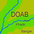 | ৪০০ × ৪০০ (২৫ KB) | smartcommons>Hunnjazal | {{Information |Description={{en|1=In North India and Pakistan, a doab is the region between two rivers (literally, do=two and ab=water). Khadir is low-lying land next to the river, and is more fertile but prone to flooding. Bangar is higher land further f |
File usage
There are no pages that use this file.
