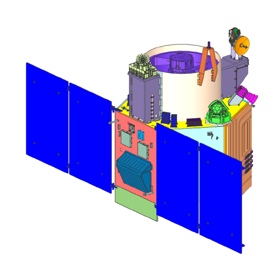
ꯐꯥꯏꯜ:Render of Cartosat-3 satellite in deployed configuration.png

ꯃꯁꯤꯒꯤ ꯄ꯭ꯔꯚꯤꯌꯨ ꯑꯁꯤꯒꯤ ꯁꯥꯏꯓ: ২২০ × ২১৭ ꯄꯤꯛꯆꯦꯜꯁ. ꯑꯇꯩ ꯁꯦꯡꯅ ꯌꯦꯡꯕ ꯌꯥꯕ: ২৪৪ × ২৪০ ꯄꯤꯛꯆꯦꯜꯁ | ৫৩৮ × ৫৩০ ꯄꯤꯛꯆꯦꯜꯁ.
ꯐꯥꯏꯜ ꯑꯁꯦꯡꯕ (৫৩৮ × ৫৩০ ꯄꯤꯛꯆꯦꯜꯁ, ꯐꯥꯏꯜ ꯆꯥꯎꯕꯒꯤ ꯆꯥꯡ: ৭৬ KB, MIME ꯃꯈꯜ: image/png)

ꯑꯇꯦꯟꯕꯥ ꯁꯟꯗꯣꯛꯅꯥ ꯇꯥꯛꯄꯥ
| ꯁꯟꯗꯣꯛꯅꯥ ꯇꯥꯛꯄꯥRender of Cartosat-3 satellite in deployed configuration.png |
English: Cartosat-3 high resolution Earth imaging satellite rendered in deployed configuration |
| ꯆꯩꯆꯠ | |
| ꯍꯧꯔꯛꯐꯛ | https://www.ursc.gov.in/earth-observation/images/cartosat3.png |
| ꯄꯨꯊꯣꯛꯂꯤꯕ ꯃꯤ | U R Rao Satellite Centre (URSC) |
ꯑꯌꯥꯕꯥ

|
This file is a copyrighted work of the Government of India, licensed under the Government Open Data License - India (GODL).
Information on Related Items:
https://data.gov.in/sites/default/files/Gazette_Notification_OGDL.pdf GODL-India Government Open Data License – India true true |
 |
| ꯈꯣꯝꯒꯠꯂꯛꯄꯥ ꯒꯤ ꯊꯧꯗꯥꯡ: U R Rao Satellite Centre (URSC) (GODL-India) | ||
|
|

|
This image, which was originally posted in the source indicated above, has not yet been reviewed by an administrator or reviewer to confirm that the above license is valid. See Category:Unreviewed photos of GODL-India for further instructions.
|
Captions
Add a one-line explanation of what this file represents
Cartosat-3 satellite in deployed configuration
ꯐꯥꯏꯜꯒꯤ ꯄꯨꯋꯥꯔꯤ
ꯆꯩꯆꯠ/ꯃꯇꯝꯗ ꯅꯝꯃꯨ ꯃꯇꯝ ꯑꯗꯨꯗ ꯐꯥꯏꯜ ꯑꯗꯨ ꯎꯅꯕ
| ꯆꯩꯆꯠ/ꯃꯇꯝ | ꯈꯨꯠꯄꯤꯈꯨꯖꯤꯟ | ꯄꯥꯛ ꯆꯥꯎꯕꯥ | ꯁꯤꯖꯤꯟꯅꯔꯤꯕ | ꯑꯄꯥꯝꯕ ꯐꯣꯡꯗꯣꯛ ꯎ | |
|---|---|---|---|---|---|
| ꯍꯧꯖꯤꯛꯀꯤ | ꯰꯱:꯰꯸, ꯴ ꯗꯤꯁꯦꯝꯕꯔ ꯲꯰꯱꯹ |  | ৫৩৮ × ৫৩০ (৭৬ KB) | smartcommons>Ohsin | Better resolution and size |
ꯐꯥꯏꯜꯒꯤ ꯁꯤꯖꯤꯟꯅꯐꯝ
ꯃꯁꯤꯒꯤ ꯐꯥꯏꯜ ꯁꯤ ꯁꯤꯖꯤꯟꯅꯕ ꯂꯃꯥꯏꯁꯤꯡ ꯂꯩꯇꯦ ꯫
