ꯐꯥꯏꯜ:Peutinger India.png


ꯐꯥꯏꯜ ꯑꯁꯦꯡꯕ (৪৬৩ × ২৪৭ ꯄꯤꯛꯆꯦꯜꯁ, ꯐꯥꯏꯜ ꯆꯥꯎꯕꯒꯤ ꯆꯥꯡ: ৪২ KB, MIME ꯃꯈꯜ: image/png)

ꯑꯇꯦꯟꯕꯥ ꯁꯟꯗꯣꯛꯅꯥ ꯇꯥꯛꯄꯥ
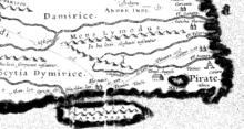
Ancient Map of India, a detail from the Roman en:Peutinger Table.
Produced around AD 300, this is the most detailed map we have of India after Ptolemy's Geographica until the Middle Ages. This detail shows only about 2% of the total Peutinger Table (Italy makes up about 40%), yet is supposed to show most of Central and all of South Asia. If turned 45 degrees the map of India become clearer, with the Ganges flowing eastward, though Sri Lanka would have to be repositioned.
ꯑꯌꯥꯕꯥ
| Public domainPublic domainfalsefalse |

|
This work is in the public domain in its country of origin and other countries and areas where the copyright term is the author's life plus 70 years or fewer.  You must also include a United States public domain tag to indicate why this work is in the public domain in the United States. You must also include a United States public domain tag to indicate why this work is in the public domain in the United States.
|
| This file has been identified as being free of known restrictions under copyright law, including all related and neighboring rights. | |
https://creativecommons.org/publicdomain/mark/1.0/PDMCreative Commons Public Domain Mark 1.0falsefalse
ꯐꯥꯏꯜꯒꯤ ꯄꯨꯋꯥꯔꯤ
ꯆꯩꯆꯠ/ꯃꯇꯝꯗ ꯅꯝꯃꯨ ꯃꯇꯝ ꯑꯗꯨꯗ ꯐꯥꯏꯜ ꯑꯗꯨ ꯎꯅꯕ
| ꯆꯩꯆꯠ/ꯃꯇꯝ | ꯈꯨꯠꯄꯤꯈꯨꯖꯤꯟ | ꯄꯥꯛ ꯆꯥꯎꯕꯥ | ꯁꯤꯖꯤꯟꯅꯔꯤꯕ | ꯑꯄꯥꯝꯕ ꯐꯣꯡꯗꯣꯛ ꯎ | |
|---|---|---|---|---|---|
| ꯍꯧꯖꯤꯛꯀꯤ | ꯱꯱:꯰꯵, ꯱꯶ ꯃꯦ ꯲꯰꯰꯶ |  | ৪৬৩ × ২৪৭ (৪২ KB) | smartcommons>Venu62~commonswiki | Ancient Map of the India. Produced around AD 300, this is the most detailed map we have of India after Ptolemy's ''Geographica'' until the Middle Ages. This map shows only about 2% of the total map (Italy makes up about 40%), yet is supposed to show most |
ꯐꯥꯏꯜꯒꯤ ꯁꯤꯖꯤꯟꯅꯐꯝ
ꯃꯁꯤꯒꯤ ꯐꯥꯏꯜ ꯁꯤ ꯁꯤꯖꯤꯟꯅꯕ ꯂꯃꯥꯏꯁꯤꯡ ꯂꯩꯇꯦ ꯫
