ꯐꯥꯏꯜ:Dissolution of Austria-Hungary.png

ꯃꯁꯤꯒꯤ ꯄ꯭ꯔꯚꯤꯌꯨ ꯑꯁꯤꯒꯤ ꯁꯥꯏꯓ: ২২০ × ১৩০ ꯄꯤꯛꯆꯦꯜꯁ. ꯑꯇꯩ ꯁꯦꯡꯅ ꯌꯦꯡꯕ ꯌꯥꯕ: ৩২০ × ১৮৯ ꯄꯤꯛꯆꯦꯜꯁ | ১,৬৪১ × ৯৭০ ꯄꯤꯛꯆꯦꯜꯁ.
ꯐꯥꯏꯜ ꯑꯁꯦꯡꯕ (১,৬৪১ × ৯৭০ ꯄꯤꯛꯆꯦꯜꯁ, ꯐꯥꯏꯜ ꯆꯥꯎꯕꯒꯤ ꯆꯥꯡ: ১৮২ KB, MIME ꯃꯈꯜ: image/png)


|
This map image could be re-created using vector graphics as a SVG file. This has several advantages; see Commons:Media for cleanup for more information. If a SVG form of this image is available, please upload it and afterwards replace this template with
{{vector version available|new image name}}.It is recommended to name the SVG file “Dissolution of Austria-Hungary.svg”—then the template Vector version available (or Vva) does not need the new image name parameter. |
| ꯁꯟꯗꯣꯛꯅꯥ ꯇꯥꯛꯄꯥDissolution of Austria-Hungary.png |
Čeština: Rozdělení Rakouska-Uherska po první světové válce, podle Pařížských předměstských smluv (Versailles s Německem, Saint-Germain-en-Laye s Rakouskem, Neuilly-sur-Seine s Bulharskem, Trianon s Maďarskem, Sèvres s Tureckem), dojednaných na Pařížské mírové konferenci (1919). Deutsch: Das Ende Österreich-Ungarns nach den Pariser Vorortverträgen. English: The end of Austria-Hungary after the Paris Treaty. |
| ꯆꯩꯆꯠ | (UTC) |
| ꯍꯧꯔꯛꯐꯛ | |
| ꯄꯨꯊꯣꯛꯂꯤꯕ ꯃꯤ |
|
| Other versions | العربيَّة |

 |
This is a retouched picture, which means that it has been digitally altered from its original version. Modifications: translated to english. The original can be viewed here: Österreich-Ungarns Ende.png:  . Modifications made by P. S. Burton. . Modifications made by P. S. Burton.
|
I, the copyright holder of this work, hereby publish it under the following licenses:
  
|
ꯐꯥꯏꯜ ꯑꯁꯤ ꯀ꯭ꯔꯤꯌꯦꯇꯤꯚ ꯀꯣꯃꯣꯟꯁꯀꯤ Attribution-Share Alike 3.0 Unported ꯑꯌꯥꯕꯒꯤ ꯃꯈꯥꯗ ꯌꯥꯎꯕꯅꯤ ꯫ | |
ꯃꯈꯥꯗ ꯎꯠꯀꯗꯕꯅꯤ ꯑꯁꯦꯡꯕ ꯑꯅꯧꯕ ꯱ ꯑꯣꯏꯅ ꯂꯧꯗꯨꯅ ꯫ | ||
| This licensing tag was added to this file as part of the GFDL licensing update.http://creativecommons.org/licenses/by-sa/3.0/CC BY-SA 3.0Creative Commons Attribution-Share Alike 3.0truetrue |

|
ꯁꯤꯟꯗꯣꯛꯅꯕ ꯑꯌꯥꯕꯗꯨ ꯄꯤꯔꯦ, ꯌꯦꯟꯊꯣꯛꯎ ꯑꯃꯁꯨꯡ/ꯅꯠꯇ꯭ꯔꯒ ꯃꯑꯣꯡ ꯱ꯗ ꯁꯦꯝꯗꯣꯛꯎ ꯃꯁꯤꯒꯤ ꯐꯥꯏꯜ ꯑꯁꯤ ꯖꯤ•ꯑꯦꯟ•ꯌꯨ ꯃꯃꯜ ꯇꯤꯡꯗꯕ ꯗꯣꯀꯨꯃꯦꯟꯇꯦꯁꯟꯒꯤ ꯑꯌꯥꯕ ꯌꯥꯅꯕꯒꯤ ꯃꯈꯥꯗ, ꯚꯔꯖꯟ ꯱.꯲ ꯅꯠꯇ꯭ꯔꯒ ꯇꯨꯡꯗ ꯂꯥꯛꯀꯗꯕ ꯚꯔꯖꯟ Free Software Foundationꯅ ꯐꯣꯡꯗꯣꯛꯂꯕ; ꯂꯣꯏꯅꯅ ꯈꯦꯠꯅꯕ ꯁꯔꯨꯛꯁꯤꯡ ꯌꯥꯎꯗꯅ, ꯂꯥꯏꯔꯤꯛꯀꯤ ꯃꯃꯥꯡꯒꯤ ꯃꯈꯨꯝ ꯌꯥꯎꯗꯕꯤ, ꯑꯃꯗꯤ ꯂꯥꯏꯔꯤꯛꯀꯤ ꯑꯔꯣꯏꯕ ꯆꯦꯈꯨꯝ ꯌꯥꯎꯗꯕꯤ ꯫ ꯁꯤꯟꯗꯣꯛꯄ ꯌꯥꯕꯒꯤ ꯑꯌꯥꯕꯁꯤꯡꯁꯤ GNU Free Documentation Licenseꯒꯤ ꯁ꯭ꯔꯨꯛꯁꯤꯡꯗ ꯌꯥꯎꯔꯦ ꯫http://www.gnu.org/copyleft/fdl.htmlGFDLGNU Free Documentation Licensetruetrue |
ꯅꯪ ꯅꯁꯥꯅꯥ ꯃꯁꯤꯒꯤ ꯑꯌꯥꯕꯁꯤ ꯈꯟꯕꯥ ꯌꯥꯅꯤ ꯫
Original upload log
This image is a derivative work of the following images:
- File:Österreich-Ungarns_Ende.png licensed with Cc-by-sa-3.0-migrated, GFDL
- 2007-07-16T11:59:46Z Nihad Hamzic 1568x970 (81916 Bytes) The original image seems to had been saved as JPEG, and that some previous uploader had simply directly converted it to PNG. I have greatly optimised its size by removing JPEG artifacts, reducing color domain, etc.
- 2006-01-23T20:47:06Z AlphaCentauri 1568x970 (924912 Bytes) kleine Änderungen
- 2005-09-23T14:27:32Z AlphaCentauri 1568x970 (924912 Bytes) Laibach and Triest
- 2005-09-17T03:29:55Z Berkut 1568x970 (355556 Bytes) better file compression
- 2005-09-16T09:39:55Z Kallgan 1568x970 (438065 Bytes) Das Ende Österreich-Ungarns nach dem Pariser Vorortverträgen. Selbsterstellte Karte. {{Bild-GFDL}} (Borders between Romania and Bulgaria in Dobrogea modified)(Source: Goode's World Atlas, Rand McNally & Company, 1932 & 19
- 2005-07-04T13:39:25Z AlphaCentauri 1568x970 (924912 Bytes) verbessert
- 2005-04-28T19:29:14Z AlphaCentauri 1568x970 (924912 Bytes) so, nochmals verbessert
- 2005-04-12T18:45:25Z AlphaCentauri 1568x970 (924912 Bytes) nochmals verbessert
- 2005-04-12T15:06:42Z AlphaCentauri 1568x970 (924912 Bytes)
- 2005-04-12T14:47:08Z AlphaCentauri 1568x970 (924912 Bytes) verbesserte Version
- 2005-01-05T20:59:50Z AlphaCentauri 1568x970 (924912 Bytes) verbesserte Version
- 2004-12-29T10:14:48Z AlphaCentauri 1568x970 (924912 Bytes) Das Ende Österreich-Ungarns (Karte)
Uploaded with derivativeFX
Captions
Add a one-line explanation of what this file represents
ꯐꯥꯏꯜꯒꯤ ꯄꯨꯋꯥꯔꯤ
ꯆꯩꯆꯠ/ꯃꯇꯝꯗ ꯅꯝꯃꯨ ꯃꯇꯝ ꯑꯗꯨꯗ ꯐꯥꯏꯜ ꯑꯗꯨ ꯎꯅꯕ
| ꯆꯩꯆꯠ/ꯃꯇꯝ | ꯈꯨꯠꯄꯤꯈꯨꯖꯤꯟ | ꯄꯥꯛ ꯆꯥꯎꯕꯥ | ꯁꯤꯖꯤꯟꯅꯔꯤꯕ | ꯑꯄꯥꯝꯕ ꯐꯣꯡꯗꯣꯛ ꯎ | |
|---|---|---|---|---|---|
| ꯍꯧꯖꯤꯛꯀꯤ | ꯲꯳:꯲꯷, ꯲꯶ ꯗꯤꯁꯦꯝꯕꯔ ꯲꯰꯲꯱ | 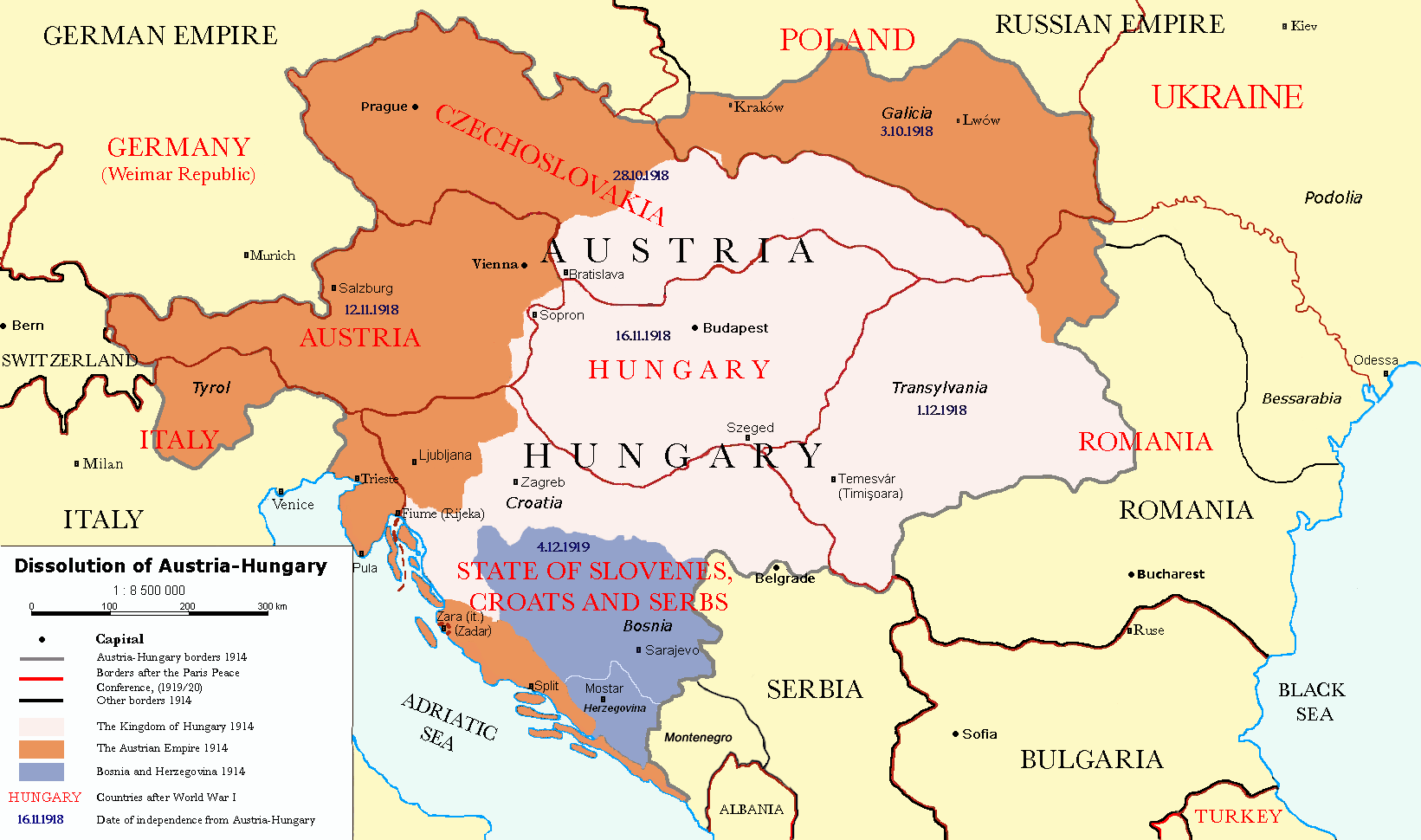 | ১,৬৪১ × ৯৭০ (১৮২ KB) | smartcommons>Claude Zygiel | Cosmetic and correct romanian-ukrainian border since April 9, 1918 |
ꯐꯥꯏꯜꯒꯤ ꯁꯤꯖꯤꯟꯅꯐꯝ
ꯃꯁꯤꯒꯤ ꯐꯥꯏꯜ ꯁꯤ ꯁꯤꯖꯤꯟꯅꯕ ꯂꯃꯥꯏꯁꯤꯡ ꯂꯩꯇꯦ ꯫
