ꯐꯥꯏꯜ:British Empire 1897.jpg

ꯃꯁꯤꯒꯤ ꯄ꯭ꯔꯚꯤꯌꯨ ꯑꯁꯤꯒꯤ ꯁꯥꯏꯓ: ২২০ × ১৬৭ ꯄꯤꯛꯆꯦꯜꯁ. ꯑꯇꯩ ꯁꯦꯡꯅ ꯌꯦꯡꯕ ꯌꯥꯕ: ৩১৬ × ২৪০ ꯄꯤꯛꯆꯦꯜꯁ | ১,১১৬ × ৮৪৯ ꯄꯤꯛꯆꯦꯜꯁ.
ꯐꯥꯏꯜ ꯑꯁꯦꯡꯕ (১,১১৬ × ৮৪৯ ꯄꯤꯛꯆꯦꯜꯁ, ꯐꯥꯏꯜ ꯆꯥꯎꯕꯒꯤ ꯆꯥꯡ: ১৫৯ KB, MIME ꯃꯈꯜ: image/jpeg)

ꯑꯇꯦꯟꯕꯥ ꯁꯟꯗꯣꯛꯅꯥ ꯇꯥꯛꯄꯥ
| ꯁꯟꯗꯣꯛꯅꯥ ꯇꯥꯛꯄꯥBritish Empire 1897.jpg |
English: The World in 1897. "The British Possessions are coloured Red" Deutsch: Weltkarte 1897. Britische Besitzungen sind rot eingezeichnet. Español: Mapa de las colonias británicas a finales del siglo XIX ქართული: მსოფლიო 1897 წელს. „წითლად ნაჩვენებია დიდი ბრიტანეთის სამფლობელოები“. |
| ꯆꯩꯆꯠ |
circa ꯱꯸꯹꯷ date QS:P,+1897-00-00T00:00:00Z/9,P1480,Q5727902 |
| ꯍꯧꯔꯛꯐꯛ | Cambridge University Library (Archived from the original) |
| ꯄꯨꯊꯣꯛꯂꯤꯕ ꯃꯤ | Unknown authorUnknown author |
ꯑꯌꯥꯕꯥ
| Public domainPublic domainfalsefalse |

|
This work is in the public domain in its country of origin and other countries and areas where the copyright term is the author's life plus 70 years or fewer.  You must also include a United States public domain tag to indicate why this work is in the public domain in the United States. You must also include a United States public domain tag to indicate why this work is in the public domain in the United States.
|
| This file has been identified as being free of known restrictions under copyright law, including all related and neighboring rights. | |
https://creativecommons.org/publicdomain/mark/1.0/PDMCreative Commons Public Domain Mark 1.0falsefalse
Captions
Add a one-line explanation of what this file represents
Mapa świata z 1897 z zaznaczonymi posiadłościami brytyjskimi (kolor czerwony)
ꯐꯥꯏꯜꯒꯤ ꯄꯨꯋꯥꯔꯤ
ꯆꯩꯆꯠ/ꯃꯇꯝꯗ ꯅꯝꯃꯨ ꯃꯇꯝ ꯑꯗꯨꯗ ꯐꯥꯏꯜ ꯑꯗꯨ ꯎꯅꯕ
| ꯆꯩꯆꯠ/ꯃꯇꯝ | ꯈꯨꯠꯄꯤꯈꯨꯖꯤꯟ | ꯄꯥꯛ ꯆꯥꯎꯕꯥ | ꯁꯤꯖꯤꯟꯅꯔꯤꯕ | ꯑꯄꯥꯝꯕ ꯐꯣꯡꯗꯣꯛ ꯎ | |
|---|---|---|---|---|---|
| ꯍꯧꯖꯤꯛꯀꯤ | ꯰꯶:꯳꯷, ꯲ ꯖꯥꯅꯨꯋꯥꯔꯤ ꯲꯰꯰꯵ | 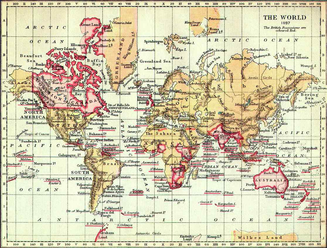 | ১,১১৬ × ৮৪৯ (১৫৯ KB) | smartcommons>Nickshanks | Taken from en: |
ꯐꯥꯏꯜꯒꯤ ꯁꯤꯖꯤꯟꯅꯐꯝ
ꯃꯁꯤꯒꯤ ꯐꯥꯏꯜ ꯁꯤ ꯁꯤꯖꯤꯟꯅꯕ ꯂꯃꯥꯏꯁꯤꯡ ꯂꯩꯇꯦ ꯫
