ꯐꯥꯏꯜ:Borneo fires October 2006.jpg

ꯃꯁꯤꯒꯤ ꯄ꯭ꯔꯚꯤꯌꯨ ꯑꯁꯤꯒꯤ ꯁꯥꯏꯓ: ২২০ × ১৬৫ ꯄꯤꯛꯆꯦꯜꯁ. ꯑꯇꯩ ꯁꯦꯡꯅ ꯌꯦꯡꯕ ꯌꯥꯕ: ৩২০ × ২৪০ ꯄꯤꯛꯆꯦꯜꯁ | ৪,০০০ × ৩,০০০ ꯄꯤꯛꯆꯦꯜꯁ.
ꯐꯥꯏꯜ ꯑꯁꯦꯡꯕ (৪,০০০ × ৩,০০০ ꯄꯤꯛꯆꯦꯜꯁ, ꯐꯥꯏꯜ ꯆꯥꯎꯕꯒꯤ ꯆꯥꯡ: ১.৯৪ MB, MIME ꯃꯈꯜ: image/jpeg)
| ꯁꯟꯗꯣꯛꯅꯥ ꯇꯥꯛꯄꯥBorneo fires October 2006.jpg |
Fires on Borneo Thick smoke hung over the island of Borneo when the Moderate Resolution Imaging Spectroradiometer (MODIS) on NASA’s Terra satellite passed overhead on October 5, 2006. The sensor detected scores of fires (locations marked in red) in the Kalimantan province of Indonesia, and smoke billowed northward over the Malaysian part of the island, as well. The fires occur annually in the dry season (August-October), caused mainly by land-clearing and other agricultural fires. Fires escape control and burn into forests and peat-swamp areas. Fires in peat—thick layers of dead, but un-decayed vegetation—are extremely smoky and difficult to put out. Some of the blazes will only be extinguished when the monsoon rains start in upcoming weeks. |
||||||
| ꯆꯩꯆꯠ | |||||||
| ꯍꯧꯔꯛꯐꯛ | http://earthobservatory.nasa.gov/NaturalHazards/natural_hazards_v2.php3?img_id=13916 | ||||||
| ꯄꯨꯊꯣꯛꯂꯤꯕ ꯃꯤ | NASA image by Jeff Schmaltz, MODIS Rapid Response Team. | ||||||
| ꯑꯌꯥꯕ ꯂꯧꯕ (ꯃꯁꯤꯒꯤ ꯐꯥꯏꯜꯁꯤ ꯑꯃꯨꯛ ꯍꯟꯅꯥ ꯁꯤꯖꯤꯟꯅꯕꯥ) |
|


العربية: دخان كثيف بعد حريق ضخم في جزيرة بورنيو عام 2006م في مقاطعة كاليمانتان في اندونيسيا.
Captions
Add a one-line explanation of what this file represents
ꯐꯥꯏꯜꯒꯤ ꯄꯨꯋꯥꯔꯤ
ꯆꯩꯆꯠ/ꯃꯇꯝꯗ ꯅꯝꯃꯨ ꯃꯇꯝ ꯑꯗꯨꯗ ꯐꯥꯏꯜ ꯑꯗꯨ ꯎꯅꯕ
| ꯆꯩꯆꯠ/ꯃꯇꯝ | ꯈꯨꯠꯄꯤꯈꯨꯖꯤꯟ | ꯄꯥꯛ ꯆꯥꯎꯕꯥ | ꯁꯤꯖꯤꯟꯅꯔꯤꯕ | ꯑꯄꯥꯝꯕ ꯐꯣꯡꯗꯣꯛ ꯎ | |
|---|---|---|---|---|---|
| ꯍꯧꯖꯤꯛꯀꯤ | ꯱꯵:꯰꯰, ꯹ ꯑꯣꯛꯇꯣꯕꯔ ꯲꯰꯰꯶ | 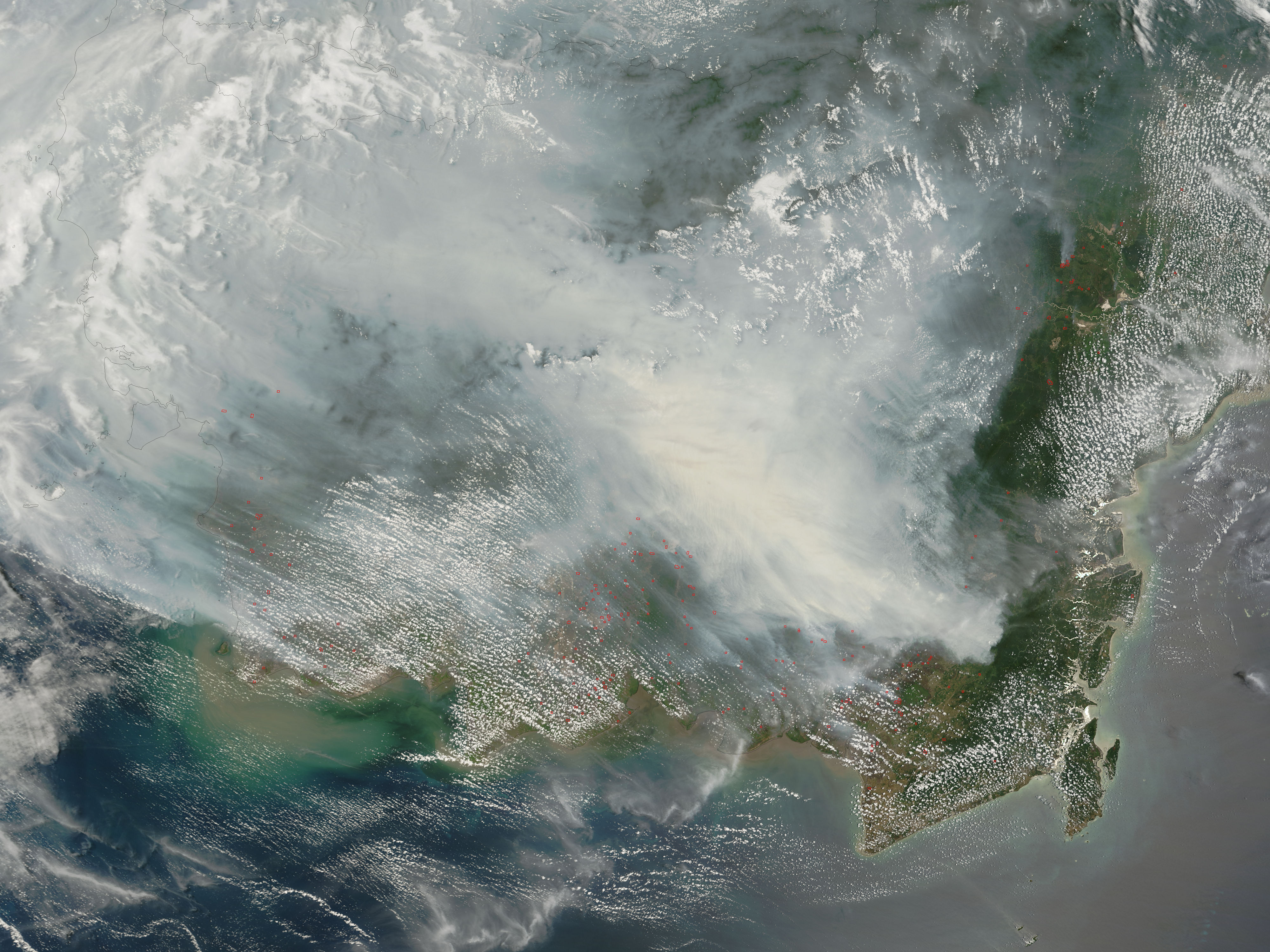 | ৪,০০০ × ৩,০০০ (১.৯৪ MB) | smartcommons>NSLE-Chacor | {{Information |Description= Fires on Borneo Thick smoke hung over the island of Borneo when the Moderate Resolution Imaging Spectroradiometer (MODIS) on NASA’s Terra satellite passed overhead on October 5, 2006. The sensor detected scores of fires (loc |
ꯐꯥꯏꯜꯒꯤ ꯁꯤꯖꯤꯟꯅꯐꯝ
ꯃꯁꯤꯒꯤ ꯐꯥꯏꯜ ꯁꯤ ꯁꯤꯖꯤꯟꯅꯕ ꯂꯃꯥꯏꯁꯤꯡ ꯂꯩꯇꯦ ꯫
