ꯐꯥꯏꯜ:AfricaMap1.jpg

ꯃꯁꯤꯒꯤ ꯄ꯭ꯔꯚꯤꯌꯨ ꯑꯁꯤꯒꯤ ꯁꯥꯏꯓ: ২২০ × ৮৩ ꯄꯤꯛꯆꯦꯜꯁ. ꯑꯇꯩ ꯁꯦꯡꯅ ꯌꯦꯡꯕ ꯌꯥꯕ: ৩২০ × ১২০ ꯄꯤꯛꯆꯦꯜꯁ | ১,২০২ × ৪৫১ ꯄꯤꯛꯆꯦꯜꯁ.
ꯐꯥꯏꯜ ꯑꯁꯦꯡꯕ (১,২০২ × ৪৫১ ꯄꯤꯛꯆꯦꯜꯁ, ꯐꯥꯏꯜ ꯆꯥꯎꯕꯒꯤ ꯆꯥꯡ: ১০১ KB, MIME ꯃꯈꯜ: image/jpeg)
| ꯁꯟꯗꯣꯛꯅꯥ ꯇꯥꯛꯄꯥAfricaMap1.jpg |
English: Graziani's advance and Wavell's offensive -- en:September 13, en:1940 - en:February 7, en:1941
Français : Avancée de l'armée italienne de Rodolfo Graziani en septembre 1940. |
||||
| ꯆꯩꯆꯠ | Unknown date, after 1938 | ||||
| ꯍꯧꯔꯛꯐꯛ | Older version of Map 34 at http://www.dean.usma.edu/history/web03/atlases/ww2%20europe/WWIIEuropeIndex.html | ||||
| ꯄꯨꯊꯣꯛꯂꯤꯕ ꯃꯤ | Department of History at the United States Military Academy | ||||
| ꯑꯌꯥꯕ ꯂꯧꯕ (ꯃꯁꯤꯒꯤ ꯐꯥꯏꯜꯁꯤ ꯑꯃꯨꯛ ꯍꯟꯅꯥ ꯁꯤꯖꯤꯟꯅꯕꯥ) |
|


|
This file was reviewed on 12 June 2009 by the administrator or trusted user Jappalang (talk), who confirmed the Public Domain status on that date.
|
Original upload log
(All user names refer to en.wikipedia)
- 2004-08-20 12:39 GeneralPatton 1202×451×8 (131506 bytes) Graziani's advance and Wavell's offensive -- [[September 13, 1940]] - [[February 7]], [[1941]]
Captions
Add a one-line explanation of what this file represents
Gen. Graziani’s attack (13 - 16 Sep 1940) followed by Gen. Wavell’s counter offensive (10 Dec. 1940 - 7 Feb 1941)
ꯐꯥꯏꯜꯒꯤ ꯄꯨꯋꯥꯔꯤ
ꯆꯩꯆꯠ/ꯃꯇꯝꯗ ꯅꯝꯃꯨ ꯃꯇꯝ ꯑꯗꯨꯗ ꯐꯥꯏꯜ ꯑꯗꯨ ꯎꯅꯕ
| ꯆꯩꯆꯠ/ꯃꯇꯝ | ꯈꯨꯠꯄꯤꯈꯨꯖꯤꯟ | ꯄꯥꯛ ꯆꯥꯎꯕꯥ | ꯁꯤꯖꯤꯟꯅꯔꯤꯕ | ꯑꯄꯥꯝꯕ ꯐꯣꯡꯗꯣꯛ ꯎ | |
|---|---|---|---|---|---|
| ꯍꯧꯖꯤꯛꯀꯤ | ꯱꯹:꯲꯲, ꯲꯷ ꯃꯥꯔꯆ ꯲꯰꯱꯱ | 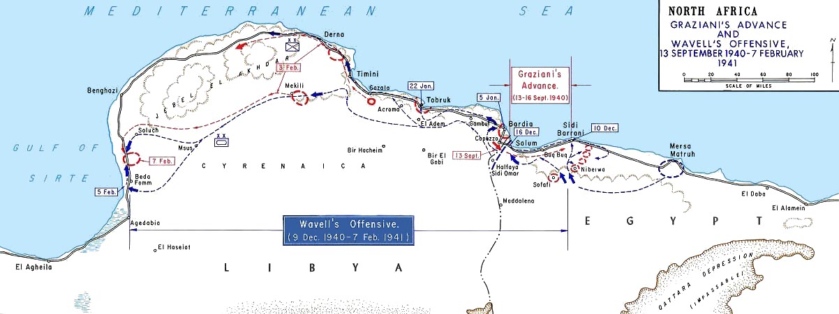 | ১,২০২ × ৪৫১ (১০১ KB) | smartcommons>Hohum | cleanup |
ꯐꯥꯏꯜꯒꯤ ꯁꯤꯖꯤꯟꯅꯐꯝ
ꯃꯁꯤꯒꯤ ꯐꯥꯏꯜ ꯁꯤ ꯁꯤꯖꯤꯟꯅꯕ ꯂꯃꯥꯏꯁꯤꯡ ꯂꯩꯇꯦ ꯫
