ꯐꯥꯏꯜ:2011 Census Scheduled Tribes distribution map India by state and union territory.svg

ꯐꯥꯏꯜ ꯑꯁꯦꯡꯕ (ꯑꯦꯁ•ꯚꯤ•ꯖꯤ ꯐꯥꯏꯜ, ꯌꯥꯝꯗꯅ ১,৫০০ × ১,৬১৫ ꯄꯤꯛꯆꯦꯜ, ꯐꯥꯏꯜ ꯆꯥꯎꯕꯒꯤ ꯆꯥꯡ: ১.৪ MB)

ꯑꯇꯦꯟꯕꯥ ꯁꯟꯗꯣꯛꯅꯥ ꯇꯥꯛꯄꯥ
| ꯁꯟꯗꯣꯛꯅꯥ ꯇꯥꯛꯄꯥ2011 Census Scheduled Tribes distribution map India by state and union territory.svg |
English: This demographic map shows Scheduled Tribes (ST) as a percent of each state and union territory's population per 2011 Census of India. Mizoram and Lakshadweep had the highest percentage Tribal populations in 2011 among all Indian states/UT (nearly 95%), while Punjab and Haryana had 0%.
Scheduled Tribes are also known as Ādivāsīs. Adivasi is an umbrella term for a heterogeneous set of ethnic and tribal groups who inhabit different parts of India. Different tribes live in mountainous northeastern states, dry areas of western states, the forests of central and eastern states, the islands of Bay of Bengal and Arabian Sea, as well as other areas. Officially recognized by the Indian government as Scheduled Tribes in the Fifth Schedule of the en:Constitution of India, they are often grouped together with scheduled castes in the category "en:Scheduled Castes and Tribes", which is eligible for certain affirmative action measures. Data Source: Census of India 2011, Primary Census Abstract - Scheduled castes and scheduled tribes, Office of the Registrar General & Census Commissioner, India (October 28 2013). The data can be viewed in a Powerpoint presentation on a Government of India Census website here. The state and disputed national borders SVG code used to create this map is a derivative work of File:India literacy rate map en.svg available on wikimedia commons. |
| ꯆꯩꯆꯠ | |
| ꯍꯧꯔꯛꯐꯛ | ꯏꯁꯥ ꯏꯊꯟꯇꯒꯤ ꯑꯣꯏꯕꯥ ꯊꯕꯛ |
| ꯄꯨꯊꯣꯛꯂꯤꯕ ꯃꯤ | M Tracy Hunter |

ꯑꯌꯥꯕꯥ


- ꯅꯪꯒꯤ ꯀꯨꯁꯤ:
- ꯃꯌꯥꯝꯗꯥ ꯐꯪꯍꯟꯕꯥ – ꯊꯥꯕꯛ ꯑꯗꯨ ꯁꯤꯟꯖꯤꯟꯕꯥ, ꯌꯦꯟꯊꯣꯛ ꯎ ꯑꯃꯥꯗꯤ ꯃꯐꯝ ꯱ ꯗꯥ ꯆꯠꯍꯟꯂꯨ
- ꯑꯃꯨꯛꯀꯥ ꯌꯥꯟꯁꯤꯟꯅꯍꯟꯕꯥ – ꯊꯥꯕꯛꯇꯨꯒꯥ ꯆꯨꯁꯤꯟꯅꯍꯟꯕꯥ
- ꯃꯈꯥꯒꯤ ꯌꯥꯅꯕꯒꯤ ꯃꯈꯥ ꯄꯣꯟꯅ:
- ꯈꯣꯝꯒꯠꯂꯛꯄꯥ – ꯅꯪꯅ ꯆꯞꯆꯥꯕ ꯇꯧꯕꯤꯃꯜ ꯄꯤꯕꯤꯒꯗꯕꯅꯤ, ꯑꯌꯥꯕ ꯄꯤꯔꯤꯕꯁꯤꯡꯒ ꯁꯝꯅꯐꯝ ꯄꯤꯒꯗꯕꯅꯤ ꯑꯃꯁꯨꯡ ꯑꯍꯣꯡꯕ ꯈꯔꯥ ꯂꯩꯔꯗꯤ ꯃꯗꯨ ꯎꯠꯀꯗꯕꯅꯤ ꯫ ꯅꯪꯅ ꯃꯗꯨ ꯃꯔꯝ ꯂꯩꯅ ꯇꯧꯒꯗꯕꯅꯤ, ꯑꯗꯨꯕꯨ ꯑꯌꯥꯕ ꯄꯥꯏꯔꯤꯕꯗꯨꯅ ꯍꯥꯏꯔꯛꯄ ꯃꯑꯣꯡ ꯅꯠꯇ꯭ꯔꯒ ꯅꯪꯅ ꯁꯤꯖꯤꯟꯅꯕ ꯃꯑꯣꯡꯗ ꯇꯧꯔꯣꯏꯗꯕꯅꯤ ꯫
- ꯃꯥꯟꯅꯕꯥ ꯁꯥꯔꯨꯛ – ꯀꯔꯤꯒꯨꯝꯅ ꯅꯪꯅ ꯌꯥꯟꯁꯤꯟꯅꯔꯕ, ꯍꯣꯡꯗꯣꯛꯍꯟꯂꯕ, ꯅꯠꯇ꯭ꯔꯒ ꯄꯣꯠꯆꯪꯁꯤꯡ ꯁꯥꯒꯠꯂꯕꯗꯤ, ꯅꯪꯒꯤ ꯍꯣꯠꯅꯖꯃꯟ ꯑꯗꯨ ꯃꯁꯤꯒꯤ same or compatible licenseꯒꯤ
Captions
ꯐꯥꯏꯜꯒꯤ ꯄꯨꯋꯥꯔꯤ
ꯆꯩꯆꯠ/ꯃꯇꯝꯗ ꯅꯝꯃꯨ ꯃꯇꯝ ꯑꯗꯨꯗ ꯐꯥꯏꯜ ꯑꯗꯨ ꯎꯅꯕ
| ꯆꯩꯆꯠ/ꯃꯇꯝ | ꯈꯨꯠꯄꯤꯈꯨꯖꯤꯟ | ꯄꯥꯛ ꯆꯥꯎꯕꯥ | ꯁꯤꯖꯤꯟꯅꯔꯤꯕ | ꯑꯄꯥꯝꯕ ꯐꯣꯡꯗꯣꯛ ꯎ | |
|---|---|---|---|---|---|
| ꯍꯧꯖꯤꯛꯀꯤ | ꯰꯲:꯵꯱, ꯲꯷ ꯖꯥꯅꯨꯋꯥꯔꯤ ꯲꯰꯲꯱ | 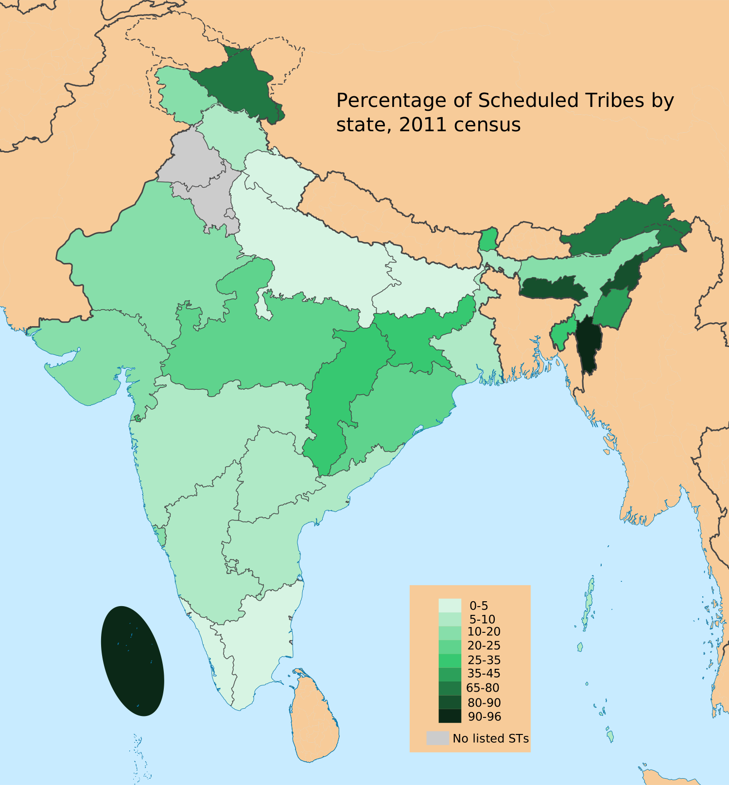 | ১,৫০০ × ১,৬১৫ (১.৪ MB) | smartcommons>C1MM | Relabeled to better show diversity |
ꯐꯥꯏꯜꯒꯤ ꯁꯤꯖꯤꯟꯅꯐꯝ
ꯃꯁꯤꯒꯤ ꯐꯥꯏꯜ ꯁꯤ ꯁꯤꯖꯤꯟꯅꯕ ꯂꯃꯥꯏꯁꯤꯡ ꯂꯩꯇꯦ ꯫
